File:Nizhnyaya Presnya housing estate plan (OSM).png
Jump to navigation
Jump to search

Size of this preview: 765 × 599 pixels. Other resolutions: 307 × 240 pixels | 613 × 480 pixels | 981 × 768 pixels | 1,280 × 1,003 pixels | 1,500 × 1,175 pixels.
Original file (1,500 × 1,175 pixels, file size: 1.26 MB, MIME type: image/png)
Captions
Captions
Add a one-line explanation of what this file represents
Summary
[edit].png&action=edit§ion=1)
| Description |
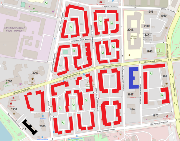
OpenStreetMap cut-out (or derivative work based on it): Русский: План посёлка (микрорайона) "Нижняя Пресня", наложенный на современную карту OSM. Красным - сохранившиеся постойки 1920-х и начала 1930-х годов. Черный - жилой дом мантулинского завода (1911 год). Синим - здание общежития, по документам 1932 года, но полностью перестроенное и перелицованное в 2000-е. This cut-out may be incomplete, and may contain errors, or may be obsolete. Don't rely solely on it for navigation. See the image in the present state and its original context on the Presnya housing estate OpenStreetMap wiki page for Nizhnyaya Presnya housing estate |
| Date | |
| Source | OpenStreetMap project data |
| Author | OpenStreetMap contributors |
| Permission (Reusing this file) |
All OpenStreetMap data and maps are licensed under: This file is licensed under the Creative Commons Attribution-Share Alike 2.0 Generic license.
|
OpenStreetMap maps of Moscow
File history
Click on a date/time to view the file as it appeared at that time.
| Date/Time | Thumbnail | Dimensions | User | Comment | |
|---|---|---|---|---|---|
| current | 11:30, 10 May 2022 | | 1,500 × 1,175 (1.26 MB) | Retired electrician (talk | contribs) | {{OpenStreetMapImage |Description={{ru|План посёлка (микрорайона) "Нижняя Пресня", наложенный на современную карту OSM. Красным - сохранившиеся постойки 1920-х и начала 1930-х годов. Черный - жилой дом мантулинского завода (1911 год). Синим - здание общежития, по документам 1932 года, но полностью перестроенное и перелицованное в 2000-е. }} |date=2022-05-10 |name=Nizhnyaya Presnya housing estate |cat=OpenStreetMap maps of Moscow }} Category:OpenStreetMap maps of Moscow [[Category:Nizhnyay... |
You cannot overwrite this file.
File usage on Commons
The following page uses this file:
File usage on other wikis
The following other wikis use this file:
- Usage on www.wikidata.org
.png&oldid=655120229)