File:Nitrogen Dioxide and Carbon Monoxide levels over India.jpg

Original file (3,508 × 2,480 pixels, file size: 7.22 MB, MIME type: image/jpeg)
Captions
Captions
Summary
[edit]
| Description |
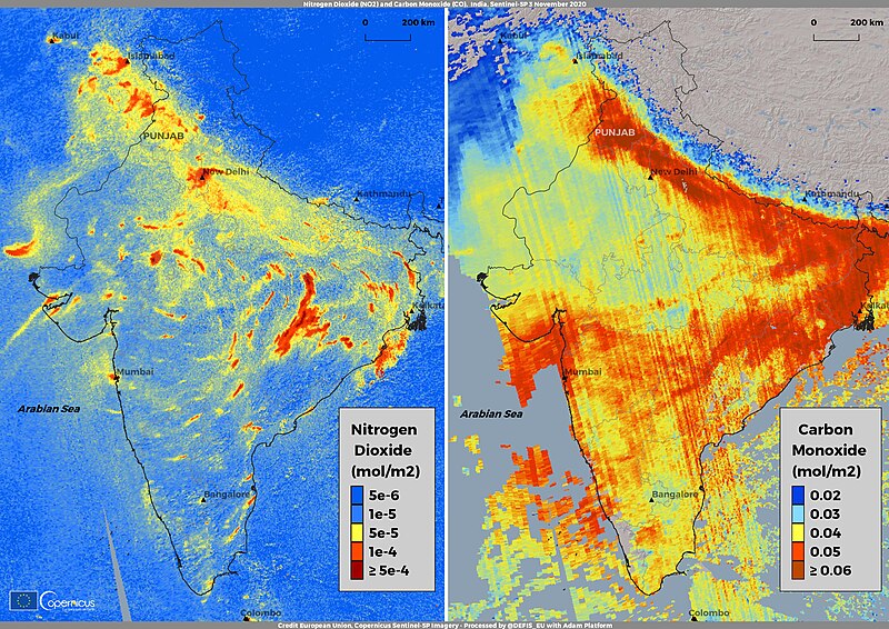
English: While winter is getting closer, the air hanging over India, especially on the north, thickens with smoke from stubble burning, mainly in the state of Punjab, blocking out the sun and making it hard to breathe. Temperatures are falling and pollution is spiking across major cities including the capital New Delhi, one of the worst-affected areas for smog from the agricultural fires. Delhi’s residents haven’t had a single day of clean air since early September, according to the World Air Quality Index, and in the last two weeks the values of measured PM2.5 have risen more than eight times above safe levels. Even if pollution is worsened by vehicle and industrial emissions, in the state of Punjab crop burning has grown exponentially since September 2020, so that the transport of smoke has been reported by satellites in different parts of the country, including southern India, reaching even the Arabian Sea. These two maps have been obtained with the data retrieved by the Copernicus Sentinel-5P mission and show the concentration of atmospheric pollutants over India, on 3 November 2020, for two different trace gases: Nitrogen Dioxide (NO2) and Carbon Monoxide (CO). While both the maps clearly show a poor air quality situation in different states across the country, the CO map clearly highlights the role of the smoke originating from the burning crops in northern India. The Sentinel-5P mission is the first Copernicus mission dedicated to monitoring our atmosphere The mission consists of one satellite carrying the TROPOspheric Monitoring Instrument (TROPOMI) instrument that performs atmospheric measurements with high spatio-temporal resolution and a global daily revisit time. The data products derived from its measurements have been specifically designed to be used for air quality, ozone & UV radiation, and climate monitoring & forecasting. |
| Date | Taken on 3 November 2020 |
| Source | Nitrogen Dioxide and Carbon Monoxide levels over India |
| Author | European Union , Copernicus Sentinel-5P imagery |
Licensing
[edit]

|
This image contains data from a satellite in the Copernicus Programme, such as Sentinel-1, Sentinel-2 or Sentinel-3. Attribution is required when using this image.
Attribution: Contains modified Copernicus Sentinel data 2020
The use of Copernicus Sentinel Data is regulated under EU law (Commission Delegated Regulation (EU) No 1159/2013 and Regulation (EU) No 377/2014). Relevant excerpts:
Free access shall be given to GMES dedicated data [...] made available through GMES dissemination platforms [...].
Access to GMES dedicated data [...] shall be given for the purpose of the following use in so far as it is lawful:
GMES dedicated data [...] may be used worldwide without limitations in time.
GMES dedicated data and GMES service information are provided to users without any express or implied warranty, including as regards quality and suitability for any purpose. |
File history
Click on a date/time to view the file as it appeared at that time.
| Date/Time | Thumbnail | Dimensions | User | Comment | |
|---|---|---|---|---|---|
| current | 08:10, 24 August 2023 | | 3,508 × 2,480 (7.22 MB) | OptimusPrimeBot (talk | contribs) | #Spacemedia - Upload of https://www.copernicus.eu/system/files/2020-11/image_day/IOTD_india_punjab.jpg via Commons:Spacemedia |
You cannot overwrite this file.
File usage on Commons
There are no pages that use this file.