File:NiigataMapCurrent.png
Jump to navigation
Jump to search

Size of this preview: 800 × 522 pixels. Other resolutions: 320 × 209 pixels | 640 × 418 pixels | 1,024 × 668 pixels | 1,381 × 901 pixels.
Original file (1,381 × 901 pixels, file size: 45 KB, MIME type: image/png)
Captions
Captions
Add a one-line explanation of what this file represents

|
This locator map image could be re-created using vector graphics as an SVG file. This has several advantages; see Commons:Media for cleanup for more information. If an SVG form of this image is available, please upload it and afterwards replace this template with
{{vector version available|new image name}}.
It is recommended to name the SVG file “NiigataMapCurrent.svg”—then the template Vector version available (or Vva) does not need the new image name parameter. |
Summary
[edit]
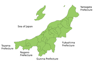
Map of Niigata Prefecture, Japan.
Thanks to Aoki Shigenobu and [1]. Colors from Image:TokyoMapCurrent.png by User:Fg2.
Licensing
[edit]
| I, the copyright holder of this work, release this work into the public domain. This applies worldwide. In some countries this may not be legally possible; if so: I grant anyone the right to use this work for any purpose, without any conditions, unless such conditions are required by law. |
File history
Click on a date/time to view the file as it appeared at that time.
| Date/Time | Thumbnail | Dimensions | User | Comment | |
|---|---|---|---|---|---|
| current | 20:46, 28 September 2011 | | 1,381 × 901 (45 KB) | Haaninjo (talk | contribs) | Mergers into Murakami (and a Kawaguchi-Nagaoka merger that didn't change any boundaries). |
| 13:27, 11 June 2007 |  | 1,381 × 901 (46 KB) | Alberth2 (talk | contribs) | ||
| 18:59, 4 April 2007 |  | 1,381 × 901 (33 KB) | Tene~commonswiki (talk | contribs) | Optimised (0) | |
| 02:50, 22 July 2006 |  | 1,381 × 901 (45 KB) | Akanemoto~commonswiki (talk | contribs) | ||
| 17:31, 19 July 2006 |  | 1,281 × 901 (43 KB) | Akanemoto~commonswiki (talk | contribs) | Map of Niigata Prefecture, Japan. Thanks to Aoki Shigenobu and [http://aoki2.si.gunma-u.ac.jp/map/map.html]. Colors from Image:TokyoMapCurrent.png by User:Fg2. Category:Maps of Niigata prefecture Category:Maps in English |
You cannot overwrite this file.
File usage on Commons
The following page uses this file:
File usage on other wikis
The following other wikis use this file:
- Usage on az.wikipedia.org
- Usage on be.wikipedia.org
- Usage on ckb.wikipedia.org
- Usage on cs.wikipedia.org
- Usage on es.wikipedia.org
- Usage on es.wikivoyage.org
- Usage on eu.wikipedia.org
- Usage on fi.wikipedia.org
- Usage on fr.wikipedia.org
- Usage on hu.wikipedia.org
- Usage on jv.wikipedia.org
- Usage on lt.wikipedia.org
- Usage on ms.wikipedia.org
- Usage on no.wikipedia.org
- Usage on pt.wikipedia.org
- Usage on ru.wikipedia.org
- Usage on th.wikipedia.org