File:Nieuwe Rielseweg 41.jpg
![File:Nieuwe Rielseweg 41.jpg](https://upload.wikimedia.org/wikipedia/commons/thumb/b/b6/Nieuwe_Rielseweg_41.jpg/450px-Nieuwe_Rielseweg_41.jpg?20170929162633)
Original file (3,480 × 4,640 pixels, file size: 5.34 MB, MIME type: image/jpeg)
Captions
Captions
Summary
[edit]DescriptionNieuwe Rielseweg 41.jpg |
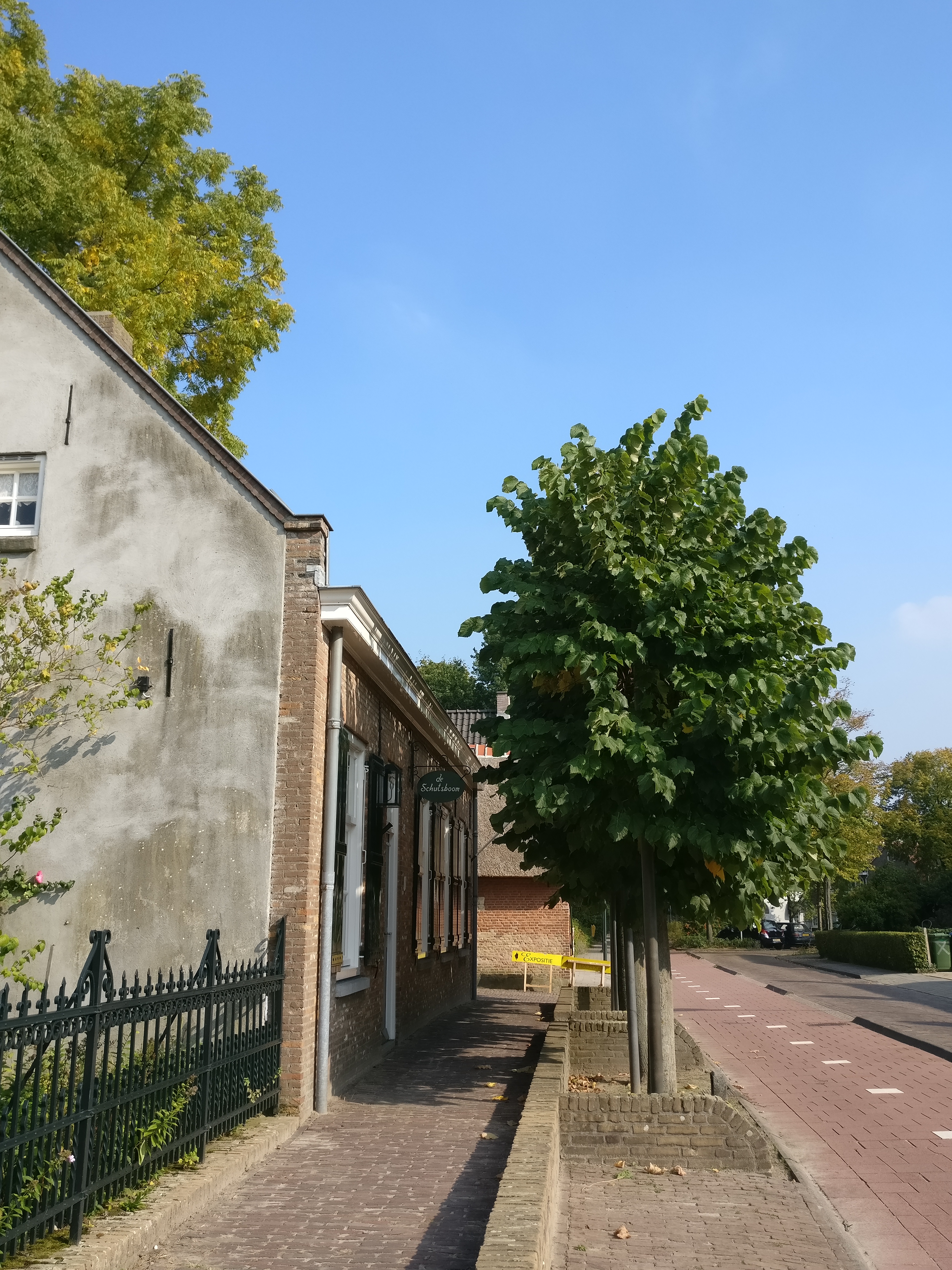
Nederlands: Het pand waarin nu het Heemkundig Museum is gevestigd, werd in 1885 gebouwd door Adriaan Stads die er een wagenmakerij en herberg exploiteerde. Het staat op de plaats van een oudere boerderij, ’t Pannenhuis;een deel daarvan is gebruikt bij de bouw van het pand in 1885. Er tegenover stond een langdeelschuur met rieten dak. Deze werd in 1890 verplaatst naar een andere hoeve, de St. Jacob, waar de eigen schuur door een windhoos was verwoest. In 1972 kwam de huidige langdeelschuur naar Goirle. Deze schuur werd in Oosterhout afgebroken en in Goirle weer als typische Brabantse langdeelschuur opgebouwd. De gebinten dateren al uit 1693. Ze hebben eerst behoord tot een schuurkerk in de gemeente Bavel.Toen de functie als kerk verviel werd ze gebruikt als boerenschuur. De schuur is dus eerder al verhuisd, namelijk van Bavel naar Oosterhout in 1852. Het museum, met schuur, karloods en naastgelegen wevershuisje ‘Het Smiske’ vormen een heel karakteristiek stukje oud Goirle.
|
||
Date | |||
Source | Own work | ||
Author | UitGoirle |
Camera location | 51° 31′ 19.65″ N, 5° 03′ 34.24″ E ![]() | View this and other nearby images on: OpenStreetMap | ![]() |
---|
Licensing
[edit]![w:en:Creative Commons](https://upload.wikimedia.org/wikipedia/commons/thumb/7/79/CC_some_rights_reserved.svg/90px-CC_some_rights_reserved.svg.png)
![attribution](https://upload.wikimedia.org/wikipedia/commons/thumb/1/11/Cc-by_new_white.svg/24px-Cc-by_new_white.svg.png)
![share alike](https://upload.wikimedia.org/wikipedia/commons/thumb/d/df/Cc-sa_white.svg/24px-Cc-sa_white.svg.png)
- You are free:
- to share – to copy, distribute and transmit the work
- to remix – to adapt the work
- Under the following conditions:
- attribution – You must give appropriate credit, provide a link to the license, and indicate if changes were made. You may do so in any reasonable manner, but not in any way that suggests the licensor endorses you or your use.
- share alike – If you remix, transform, or build upon the material, you must distribute your contributions under the same or compatible license as the original.
![]() |
This image was uploaded as part of Wiki Loves Monuments 2017.
Afrikaans ∙ Alemannisch ∙ azərbaycanca ∙ Bahasa Indonesia ∙ Bahasa Melayu ∙ Bikol Central ∙ bosanski ∙ brezhoneg ∙ català ∙ čeština ∙ Cymraeg ∙ dansk ∙ davvisámegiella ∙ Deutsch ∙ eesti ∙ English ∙ español ∙ Esperanto ∙ euskara ∙ français ∙ Frysk ∙ Gaeilge ∙ galego ∙ hrvatski ∙ Ido ∙ italiano ∙ latviešu ∙ Lëtzebuergesch ∙ Malagasy ∙ magyar ∙ Malti ∙ Nederlands ∙ norsk ∙ norsk nynorsk ∙ norsk bokmål ∙ polski ∙ português ∙ português do Brasil ∙ română ∙ shqip ∙ sicilianu ∙ slovenčina ∙ slovenščina ∙ suomi ∙ svenska ∙ Tagalog ∙ Türkçe ∙ Yorùbá ∙ Zazaki ∙ Ελληνικά ∙ беларуская ∙ беларуская (тарашкевіца) ∙ български ∙ кыргызча ∙ македонски ∙ русский ∙ српски / srpski ∙ українська ∙ ქართული ∙ հայերեն ∙ नेपाली ∙ हिन्दी ∙ বাংলা ∙ മലയാളം ∙ ไทย ∙ 한국어 ∙ +/− |
![]() |
File history
Click on a date/time to view the file as it appeared at that time.
Date/Time | Thumbnail | Dimensions | User | Comment | |
---|---|---|---|---|---|
current | 16:26, 29 September 2017 | ![]() | 3,480 × 4,640 (5.34 MB) | UitGoirle (talk | contribs) | User created page with UploadWizard |
You cannot overwrite this file.
File usage on Commons
There are no pages that use this file.
Metadata
This file contains additional information such as Exif metadata which may have been added by the digital camera, scanner, or software program used to create or digitize it. If the file has been modified from its original state, some details such as the timestamp may not fully reflect those of the original file. The timestamp is only as accurate as the clock in the camera, and it may be completely wrong.
Camera manufacturer | OnePlus |
---|---|
Camera model | ONEPLUS A3003 |
Exposure time | 1/773 sec (0.0012936610608021) |
F-number | f/2 |
ISO speed rating | 100 |
Date and time of data generation | 15:34, 24 September 2017 |
Lens focal length | 4.26 mm |
Latitude | 51° 31′ 19.65″ N |
Longitude | 5° 3′ 34.24″ E |
Altitude | 65 meters above sea level |
Horizontal resolution | 72 dpi |
Vertical resolution | 72 dpi |
Software used | OnePlus3-user 7.1.1 NMF26F 87 dev-keys |
File change date and time | 15:34, 24 September 2017 |
Y and C positioning | Centered |
Exposure Program | Not defined |
Exif version | 2.2 |
Date and time of digitizing | 15:34, 24 September 2017 |
Meaning of each component |
|
APEX shutter speed | 9.595 |
APEX aperture | 2 |
APEX brightness | 0 |
Metering mode | Spot |
Flash | Flash did not fire, compulsory flash suppression |
DateTime subseconds | 973683 |
DateTimeOriginal subseconds | 973683 |
DateTimeDigitized subseconds | 973683 |
Supported Flashpix version | 1 |
Color space | sRGB |
Sensing method | One-chip color area sensor |
Scene type | A directly photographed image |
Exposure mode | Auto exposure |
White balance | Auto white balance |
Focal length in 35 mm film | 28 mm |
Scene capture type | Standard |
GPS time (atomic clock) | 13:34 |
GPS date | 24 September 2017 |
Structured data
Items portrayed in this file
depicts
51°31'19.650"N, 5°3'34.240"E
24 September 2017
0.00129366106080206985 second
4.26 millimetre
100
- Gemeentelijke monumenten with known IDs
- Gemeentelijke monumenten missing SDC depicts
- Gemeentelijke monumenten missing SDC location of creation
- Files with coordinates missing SDC location of creation (51° N, 5° E)
- CC-BY-SA-4.0
- Self-published work
- Images from Wiki Loves Monuments 2017
- Images from Wiki Loves Monuments 2017 in the Netherlands
- Images from Wiki Loves Monuments missing SDC depicts
- Images from Wiki Loves Monuments missing SDC location of creation
- Uploaded via Campaign:wlm-nl-gemeente
- New images from Wiki Loves Monuments 2017 in the Netherlands
- Netherlands photographs taken on 2017-09-24