File:NicoDitch.jpg
Jump to navigation
Jump to search
No higher resolution available.
NicoDitch.jpg (640 × 480 pixels, file size: 148 KB, MIME type: image/jpeg)
Captions
Captions
Add a one-line explanation of what this file represents
Summary
[edit]
| Description |
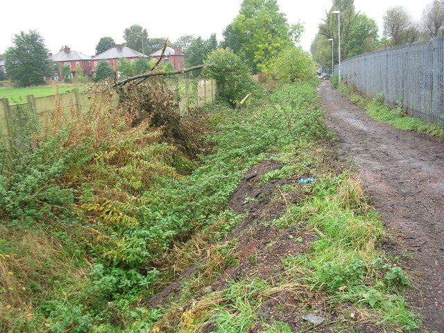
English: Nico Ditch Looking west along Nico Ditch near Levenshulme, Manchester. The public footpath seen here runs between the ditch on the left and Mellands Playing Field which lies beyond the fence on the right. About 200-300 metres of the ditch survive here and little elsewhere. This ditch is believed to have been a defensive earthwork dug in a single night as protection against the Danish invasion of 869-870 AD. It varied in width and depth, but averaged between 2 and 2.5 metres deep, and extended for over five miles in length between marshes in Fallowfield and Audenshaw. SJ88249487. |
| Date | |
| Source | From geograph.org.uk |
| Author | Keith Williamson |
| Camera location | | View this and other nearby images on: OpenStreetMap |
|---|
Licensing
[edit]

|
This image was taken from the Geograph project collection. See this photograph's page on the Geograph website for the photographer's contact details. The copyright on this image is owned by Keith Williamson and is licensed for reuse under the Creative Commons Attribution-ShareAlike 2.0 license.
|
This file is licensed under the Creative Commons Attribution-Share Alike 2.0 Generic license.
Attribution: Keith Williamson
- You are free:
- to share – to copy, distribute and transmit the work
- to remix – to adapt the work
- Under the following conditions:
- attribution – You must give appropriate credit, provide a link to the license, and indicate if changes were made. You may do so in any reasonable manner, but not in any way that suggests the licensor endorses you or your use.
- share alike – If you remix, transform, or build upon the material, you must distribute your contributions under the same or compatible license as the original.
File history
Click on a date/time to view the file as it appeared at that time.
| Date/Time | Thumbnail | Dimensions | User | Comment | |
|---|---|---|---|---|---|
| current | 18:36, 15 December 2007 | | 640 × 480 (148 KB) | Malleus Fatuarum (talk | contribs) | {{Information |Description=Looking west along Nico Ditch, near Levenshulme |Source=www.geograph.co.uk |Date=2007-12014 |Author=Keith Williamson |Permission= |other_versions= }} |
You cannot overwrite this file.
File usage on Commons
The following page uses this file:
File usage on other wikis
The following other wikis use this file:
- Usage on de.wikipedia.org
- Usage on en.wikipedia.org
- History of Manchester
- Portal:Geography/Featured article/archive
- Nico Ditch
- Portal:Greater Manchester
- Scheduled monuments in Greater Manchester
- Portal:Geography/Featured article/January, 2012
- Wikipedia:Today's featured article/November 2018
- Wikipedia:Today's featured article/November 23, 2018
- Wikipedia:Main Page history/2018 November 23
- Usage on es.wikipedia.org
- Usage on fr.wikipedia.org
- Usage on id.wikipedia.org
- Usage on la.wikipedia.org
- Usage on pt.wikipedia.org
- Usage on simple.wikipedia.org
- Usage on tn.wikipedia.org
- Usage on uz.wikipedia.org
- Usage on www.wikidata.org