File:Niblick Shoal - Subsurface Layout.svg
Jump to navigation
Jump to search

Size of this PNG preview of this SVG file: 272 × 303 pixels. Other resolutions: 215 × 240 pixels | 431 × 480 pixels | 689 × 768 pixels | 919 × 1,024 pixels | 1,838 × 2,048 pixels.
Original file (SVG file, nominally 272 × 303 pixels, file size: 612 KB)
Captions
Captions
Add a one-line explanation of what this file represents

| Description |
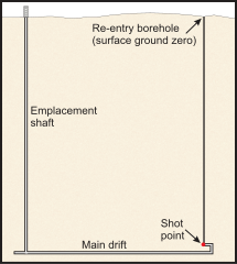
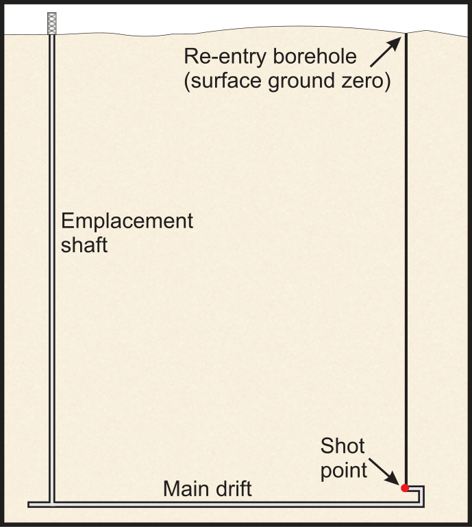
English: Niblick Shoal underground test. Subsurface layout. |
|||
| Source | Shoal Site Fact Sheet | |||
| Author | Federal Government of the United States | |||
| Permission (Reusing this file) |
|

File history
Click on a date/time to view the file as it appeared at that time.
| Date/Time | Thumbnail | Dimensions | User | Comment | |
|---|---|---|---|---|---|
| current | 16:14, 19 September 2011 | | 272 × 303 (612 KB) | Bomazi (talk | contribs) | {{Information |Description ={{en|1=Niblick Shoal underground test. Subsurface layout.}} |Source =http://www.lm.doe.gov/shoal/Sites.aspx |Author =Federal Government of the United States |Date = |Permission ={{PD-USGov-DOE}} |
You cannot overwrite this file.
File usage on Commons
There are no pages that use this file.
File usage on other wikis
The following other wikis use this file:
- Usage on fr.wikipedia.org