File:Niagara Falls International Rainbow Bridge Between Niagara Falls, New York and Niagara Falls, Ontario (29357645834).jpg

Original file (4,000 × 3,000 pixels, file size: 2.79 MB, MIME type: image/jpeg)
Captions
Captions
Summary
[edit].jpg&action=edit§ion=1)
| Description |
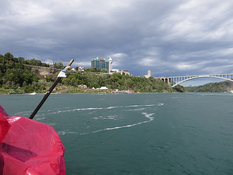
The Niagara Falls International Rainbow Bridge, commonly known as the Rainbow Bridge, is an arch bridge across the Niagara River gorge, and is a world-famous tourist site. It connects the cities of Niagara Falls, New York, United States (to the east), and Niagara Falls, Ontario, Canada (west). The Rainbow Bridge was built near the site of the earlier Honeymoon Bridge, which collapsed on January 27, 1938, due to an ice jam in the river. A joint Canadian and American commission had been considering a new bridge to replace it, and the collapse added urgency to the project. The bridge permits no commercial trucks; the nearest border crossing for these is the Lewiston-Queenston Bridge.[5] The toll to cross the bridge for each pedestrian and bicycle is $1.00 US or CAD, and $3.75 US or $5.00 CAD for automobiles as of February 2018. Car tolls are collected when leaving the United States. Pedestrian toll is collected by an automatic turnstile when leaving Canada, payable in U.S. or CAD quarters or $1 CAD 'loonies'.[2] Change machines are available from $1 and $5 US bills and $1 (loonies) and $2 (toonies) Canadian coins. <a href="https://en.wikipedia.org/wiki/Rainbow_Bridge_" rel="noreferrer nofollow">en.wikipedia.org/wiki/Rainbow_Bridge_</a>(Niagara_Falls) <a href="https://en.wikipedia.org/wiki/Wikipedia:Text_of_Creative_Commons_Attribution-ShareAlike_3.0_Unported_License" rel="noreferrer nofollow">en.wikipedia.org/wiki/Wikipedia:Text_of_Creative_Commons_...</a> |
| Date | |
| Source | Niagara Falls International Rainbow Bridge Between Niagara Falls, New York and Niagara Falls, Ontario |
| Author | Ken Lund from Reno, Nevada, USA |
| Camera location | | View this and other nearby images on: OpenStreetMap |
|---|
.jpg¶ms=043.084138_N_-079.072948_E_globe:Earth_type:camera_source:Flickr_&language=en)
Licensing
[edit].jpg&action=edit§ion=2)
- You are free:
- to share – to copy, distribute and transmit the work
- to remix – to adapt the work
- Under the following conditions:
- attribution – You must give appropriate credit, provide a link to the license, and indicate if changes were made. You may do so in any reasonable manner, but not in any way that suggests the licensor endorses you or your use.
- share alike – If you remix, transform, or build upon the material, you must distribute your contributions under the same or compatible license as the original.
| This image was originally posted to Flickr by Ken Lund at https://flickr.com/photos/75683070@N00/29357645834. It was reviewed on 10 March 2022 by FlickreviewR 2 and was confirmed to be licensed under the terms of the cc-by-sa-2.0. |
File history
Click on a date/time to view the file as it appeared at that time.
| Date/Time | Thumbnail | Dimensions | User | Comment | |
|---|---|---|---|---|---|
| current | 19:24, 10 March 2022 | | 4,000 × 3,000 (2.79 MB) | Mindmatrix (talk | contribs) | Transferred from Flickr via #flickr2commons |
You cannot overwrite this file.
File usage on Commons
There are no pages that use this file.
.jpg&oldid=881066190)