File:New River ACEC (15517471967).jpg

Original file (5,550 × 2,090 pixels, file size: 8.52 MB, MIME type: image/jpeg)
Captions
Captions
Summary
[edit].jpg&action=edit§ion=1)
| Description |
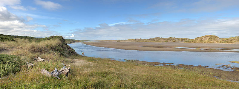
Running parallel to the Pacific Ocean for nine miles, this coastal river is separated from the ocean by only a thin foredune of sand. Many rare birds, animals, and plants depend on New River's estuary, forest, meadow, wetland, and shrub habitat for survival. Dedicated almost exclusively to Watchable Wildlife, the area remains secluded and primitive, providing nature enthusiasts with short, rustic, self-guided loop trails to view wildlife. There are four main access points to New River ACEC, Storm Ranch, Floras Lake, Lost Lake, and Four Mile. For more information, visit on.doi.gov/1GfG7ds Photo by Frank Price |
| Date | |
| Source | New River ACEC |
| Author | Bureau of Land Management Oregon and Washington |
| Camera location | | View this and other nearby images on: OpenStreetMap |
|---|
.jpg¶ms=043.023847_N_0124.447161_E_globe:Earth_type:camera_source:Flickr_&language=en)
Licensing
[edit].jpg&action=edit§ion=2)
- You are free:
- to share – to copy, distribute and transmit the work
- to remix – to adapt the work
- Under the following conditions:
- attribution – You must give appropriate credit, provide a link to the license, and indicate if changes were made. You may do so in any reasonable manner, but not in any way that suggests the licensor endorses you or your use.
| This image was originally posted to Flickr by BLMOregon at https://flickr.com/photos/50169152@N06/15517471967. It was reviewed on 10 December 2015 by FlickreviewR and was confirmed to be licensed under the terms of the cc-by-2.0. |
| This image is a work of a Bureau of Land Management* employee, taken or made as part of that person's official duties. As a work of the U.S. federal government, the image is in the public domain in the United States. *or predecessor organization |
File history
Click on a date/time to view the file as it appeared at that time.
| Date/Time | Thumbnail | Dimensions | User | Comment | |
|---|---|---|---|---|---|
| current | 05:52, 10 December 2015 | 5,550 × 2,090 (8.52 MB) | Holly Cheng (talk | contribs) | Transferred from Flickr via Flickr2Commons |
You cannot overwrite this file.
File usage on Commons
There are no pages that use this file.
.jpg&oldid=463969697)