File:New Jersey Counties by metro area labeled.svg
Jump to navigation
Jump to search

Size of this PNG preview of this SVG file: 316 × 598 pixels. Other resolutions: 127 × 240 pixels | 253 × 480 pixels | 405 × 768 pixels | 541 × 1,024 pixels | 1,081 × 2,048 pixels | 1,426 × 2,700 pixels.
Original file (SVG file, nominally 1,426 × 2,700 pixels, file size: 153 KB)
Captions
Captions
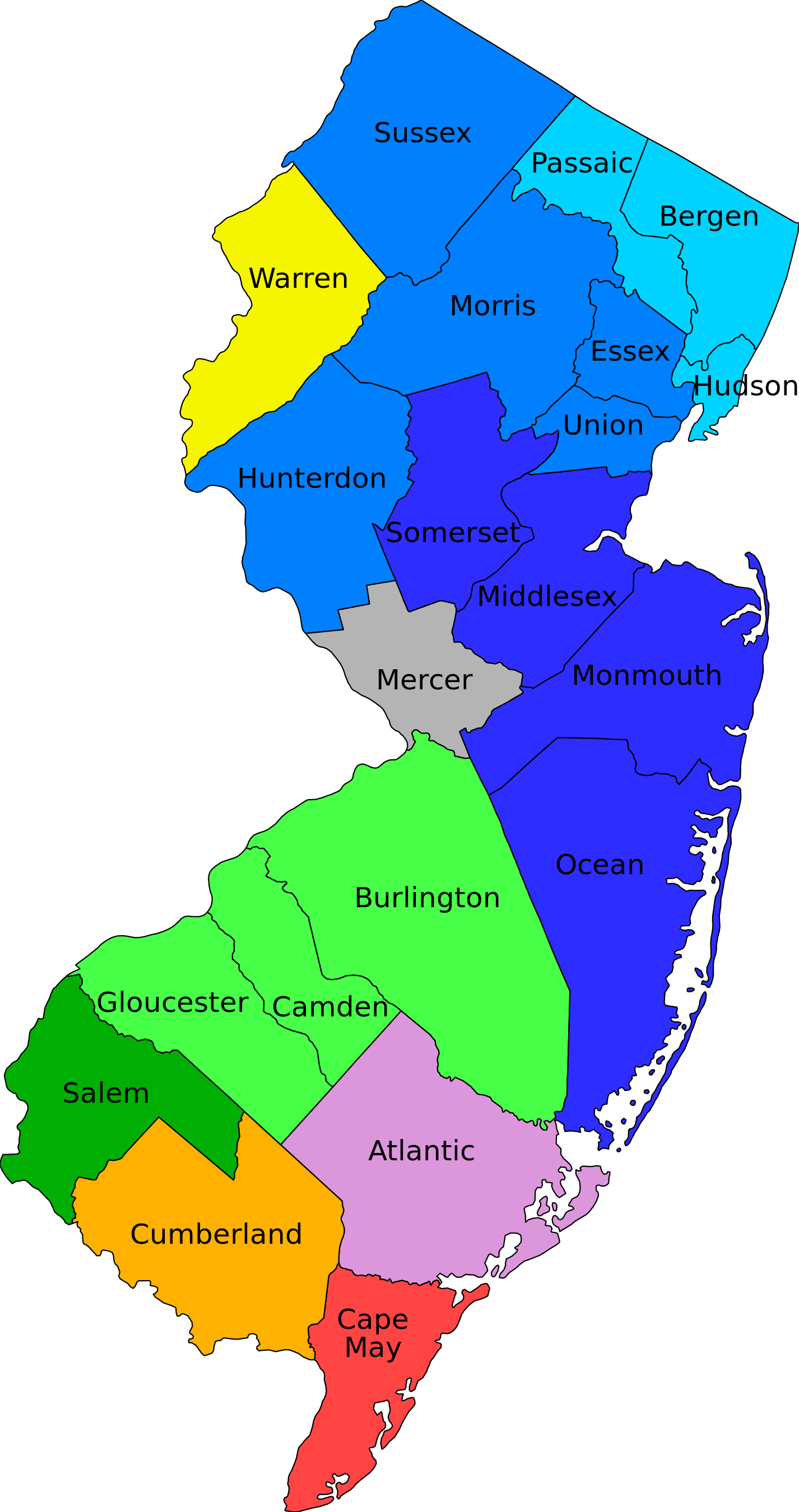
New Jersey Counties Map by metro area labeled.
Summary
[edit]
New Jersey Counties, labeled, shaded by en:Metropolitan Statistical Area Divisions
- Image source: File:New Jersey Counties Labeled.svg
- Data source: en:U.S. Census Bureau [1], originally from en:Office of Management and Budget
- Allentown-Bethlehem-Easton, PA-NJ Metropolitan Statistical Area
- Warren
- Atlantic City, NJ Metropolitan Statistical Area
- Atlantic
- New York-Northern New Jersey-Long Island, NY-NJ-PA Metropolitan Statistical Area
- New York-White Plains-Wayne, NY-NJ Metropolitan Division
- Bergen
- Hudson
- Passaic
- Edison-Woodbridge-Fords, NJ Metropolitan Division
- Middlesex
- Monmouth
- Ocean
- Somerset
- Newark-Union, NJ-PA Metropolitan Division
- Essex
- Hunterdon
- Morris
- Sussex
- Union
- New York-White Plains-Wayne, NY-NJ Metropolitan Division
- Ocean City, NJ Metropolitan Statistical Area
- Cape May
- Philadelphia-Camden-Wilmington, PA-NJ-DE-MD Metropolitan Statistical Area
- Camden, NJ Metropolitan Division
- Burlington
- Camden
- Gloucester
- Wilmington, DE-MD-NJ Metropolitan Division
- Salem
- Camden, NJ Metropolitan Division
- Trenton-Ewing, NJ Metropolitan Statistical Area
- Mercer
- Vineland-Millville-Bridgeton, NJ Metropolitan Statistical Area
- Cumberland
Licensing
[edit]
| I, the copyright holder of this work, release this work into the public domain. This applies worldwide. In some countries this may not be legally possible; if so: I grant anyone the right to use this work for any purpose, without any conditions, unless such conditions are required by law. |
File history
Click on a date/time to view the file as it appeared at that time.
| Date/Time | Thumbnail | Dimensions | User | Comment | |
|---|---|---|---|---|---|
| current | 04:23, 9 December 2006 | | 1,426 × 2,700 (153 KB) | ChrisRuvolo (talk | contribs) | changed colors to make more clear what the divisions are |
| 21:23, 8 December 2006 |  | 1,426 × 2,700 (153 KB) | ChrisRuvolo (talk | contribs) | New Jersey Counties, labeled, shaded by en:Metropolitan Statistical Area Divisions Category:Maps of New Jersey Category:Counties in New Jersey |
You cannot overwrite this file.
File usage on Commons
The following 3 pages use this file:
File usage on other wikis
The following other wikis use this file:
- Usage on bg.wikipedia.org
- Usage on ca.wikipedia.org
- Usage on da.wikipedia.org
- Usage on el.wikipedia.org
- Usage on en.wikipedia.org
- Usage on fa.wikipedia.org
- Usage on hu.wikipedia.org
- Usage on id.wikipedia.org
- Usage on ja.wikipedia.org
- Usage on no.wikipedia.org
- Usage on tr.wikipedia.org
- Usage on zh.wikipedia.org