File:Network map ESA286082.png

Original file (2,482 × 1,520 pixels, file size: 3.28 MB, MIME type: image/png)
Captions
Captions
Summary
[edit]
| Description |
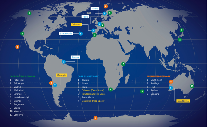
English: Map showing locations of ESA tracking (Estrack) stations as of 2017. Note this map is representational only and not all locations are shown with complete accuracy.
Blue indicates core ESA-owned stations operated by the Estrack Network Operations Centre (NOC) located at ESA’s European Space Operations Centre (ESOC), Darmstadt, Germany. Orange indicates Augmented Estrack stations, procured commercially and operated on behalf of ESA by commercial entities. Green indicates Cooperative Estrack stations owned and operated by external agencies, but regularly providing services to ESA missions on an exchange basis. The ESA tracking station at Perth, Australia, was retired from service in December 2015. The ESA stations at Villafranca and Maspalomas, Spain, were transferred to industry in 2017. More information Deep space tracking stations via Google maps |
| Date | |
| Source | http://www.esa.int/spaceinimages/Images/2013/01/Network_map |
| Author | European Space Agency |
| Permission (Reusing this file) |
ESA,CC BY-SA 3.0 IGO |
| Title | Network map |
| System | ESTRACK |
| Activity | Operations |
Licensing
[edit]
- You are free:
- to share – to copy, distribute and transmit the work
- to remix – to adapt the work
- Under the following conditions:
- attribution – You must give appropriate credit, provide a link to the license, and indicate if changes were made. You may do so in any reasonable manner, but not in any way that suggests the licensor endorses you or your use.
- share alike – If you remix, transform, or build upon the material, you must distribute your contributions under the same or compatible license as the original.
File history
Click on a date/time to view the file as it appeared at that time.
| Date/Time | Thumbnail | Dimensions | User | Comment | |
|---|---|---|---|---|---|
| current | 15:14, 30 December 2017 | | 2,482 × 1,520 (3.28 MB) | Fæ (talk | contribs) | European Space Agency, Id 286082, http://www.esa.int/spaceinimages/Images/2013/01/Network_map, User:Fæ/Project_list/ESA |
You cannot overwrite this file.
File usage on Commons
The following page uses this file:
File usage on other wikis
The following other wikis use this file: