File:Netley1860map.jpg
Jump to navigation
Jump to search
Size of this preview: 760 × 600 pixels. Other resolutions: 304 × 240 pixels | 608 × 480 pixels | 973 × 768 pixels | 1,280 × 1,010 pixels | 2,560 × 2,021 pixels | 5,884 × 4,645 pixels.
Original file (5,884 × 4,645 pixels, file size: 4.13 MB, MIME type: image/jpeg)
Captions
Captions
Add a one-line explanation of what this file represents
Summary
[edit]
| Description |
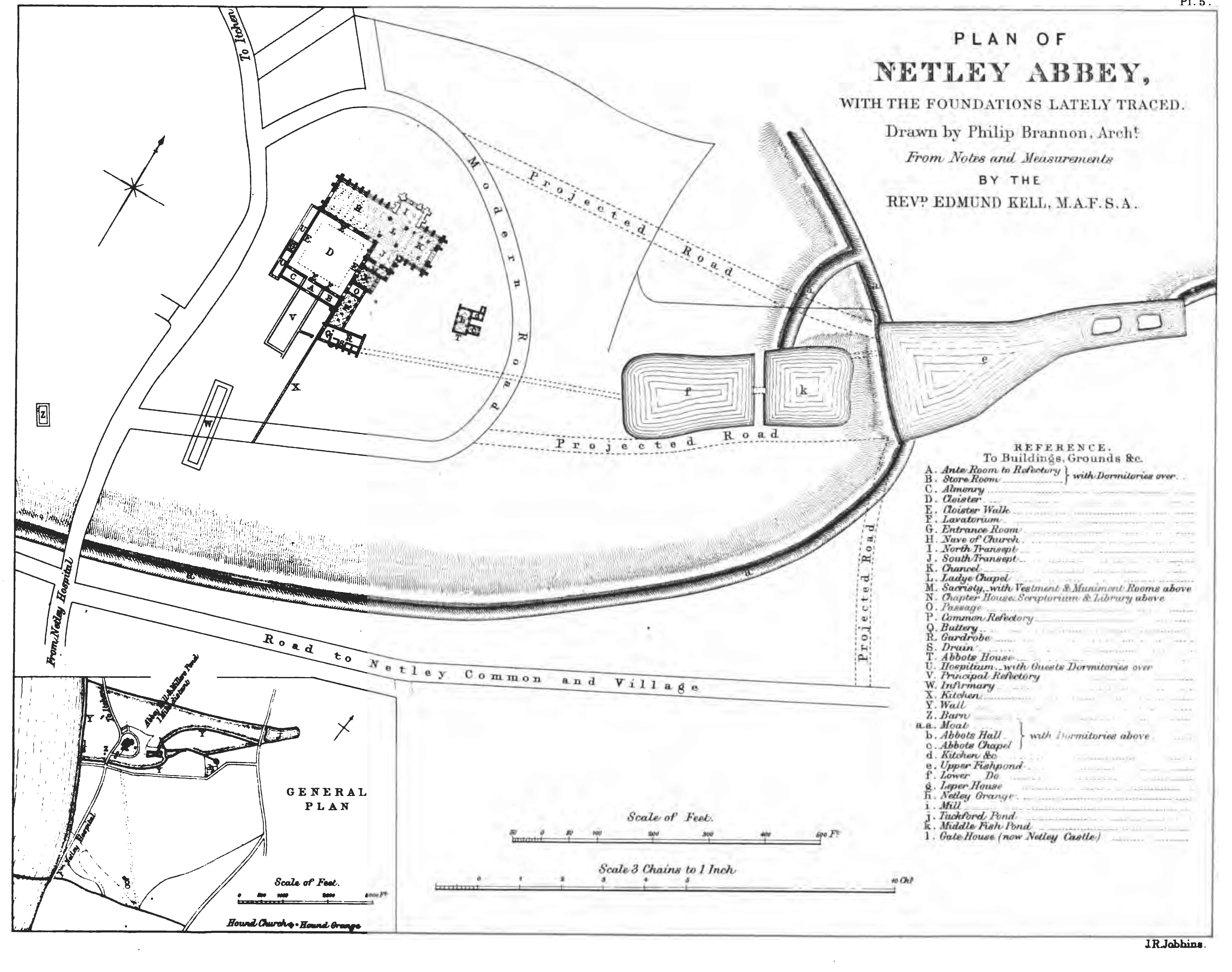
English: Plan of the abbey and its precinct at the time of the 1860 excavations. Of particular interest are the line of the moat and the three fishponds and the location of the two precinct buildings south of the abbey. The area has been much built up since then and much of this evidence has disappeared beneath modern development. |
| Date | |
| Source | Netley Abbey, with an Account of Recent Excavations and Discoveries, in Collectanea Archaeologica: communications made to the British Archaeological Association Volume II Part i, by Revd. Edmund Kell |
| Author | Drawn by Phillip Brannon, engraved by J. R. Jubbins |
Licensing
[edit]
|
This work is in the public domain in its country of origin and other countries and areas where the copyright term is the author's life plus 70 years or fewer. | |
| This file has been identified as being free of known restrictions under copyright law, including all related and neighboring rights. | |
File history
Click on a date/time to view the file as it appeared at that time.
| Date/Time | Thumbnail | Dimensions | User | Comment | |
|---|---|---|---|---|---|
| current | 02:40, 4 January 2009 | | 5,884 × 4,645 (4.13 MB) | Faeriesoph (talk | contribs) | {{Information |Description={{en|1=Plan of the abbey and its precinct at the time of the 1860 excavations. Of particular interest is the line of the moat and the three fishponds and the location of the two precinct buildings south of the abbey. The area ha |
You cannot overwrite this file.
File usage on Commons
The following page uses this file: