File:Netherlands, Noordbroek, map of 1867.jpg
Jump to navigation
Jump to search

Size of this preview: 680 × 600 pixels. Other resolutions: 272 × 240 pixels | 544 × 480 pixels | 871 × 768 pixels | 1,161 × 1,024 pixels | 1,400 × 1,235 pixels.
Original file (1,400 × 1,235 pixels, file size: 351 KB, MIME type: image/jpeg)
Captions
Captions
Add a one-line explanation of what this file represents
Summary
[edit]
| Description |
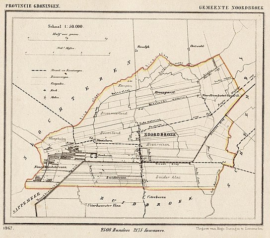
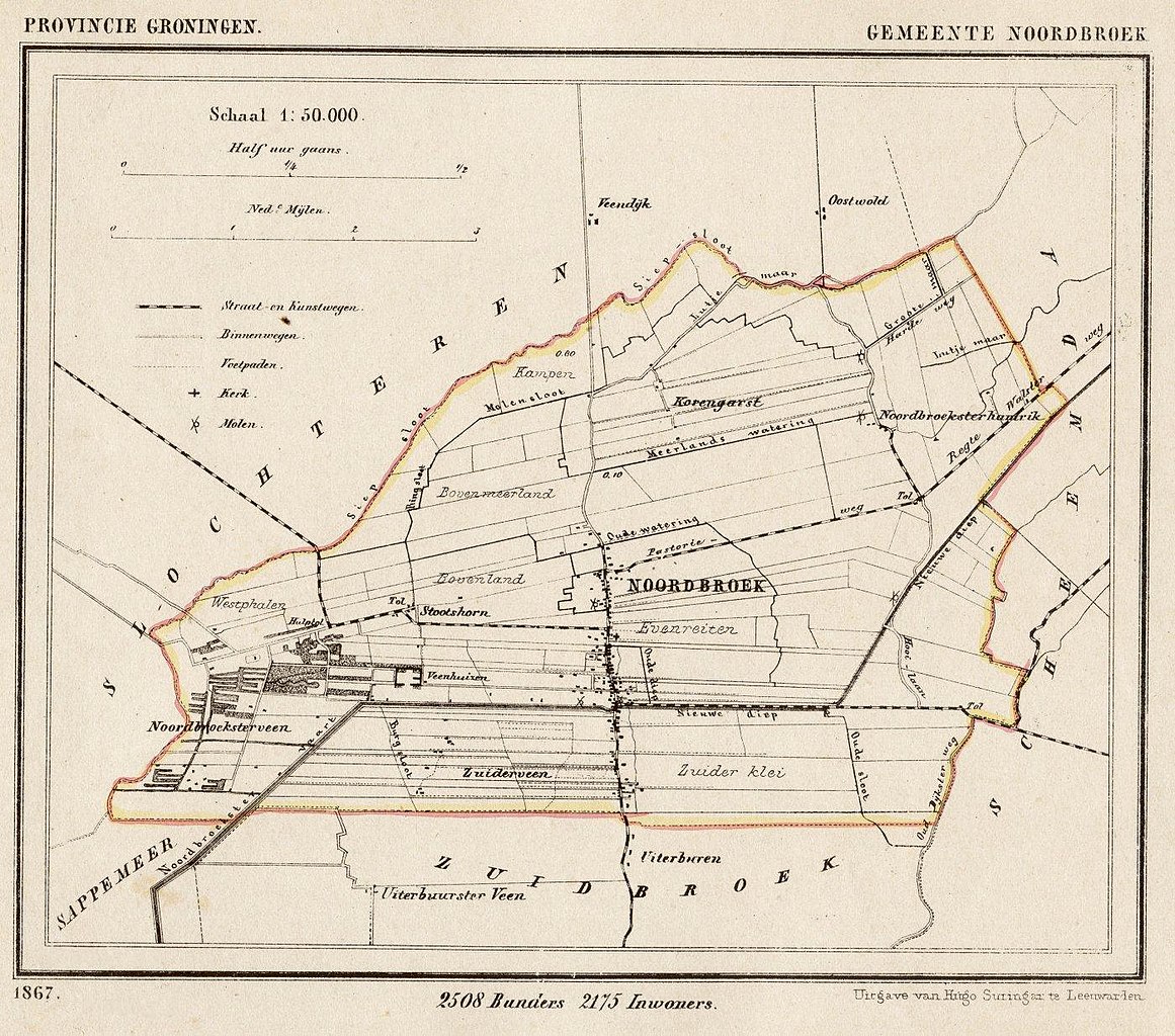
Nederlands: Kaart uit 1867 van de voormalige gemeente Noordbroek (prov. Groningen). Tot 1965 was Noordbroek een zelfstandige gemeente, inclusief de gehuchten Stootshorn en Hamrik. In dat jaar vormde Noordbroek met Zuidbroek de gemeente Oosterbroek, die in 1989 fuseerde met Muntendam en Meeden tot de huidige gemeente Menterwolde.
English: Map from 1867 of the former municipality of Noordbroek (Province of Groningen, Netherlands). Noordbroek remained an independent municipality until 1965 and included the hamlets of Hamrik and Stootshoorn. That year Noordbroek and neighbouring Zuidbroek joined to form the municipality of Oosterbroek, which in turn merged in 1989 with Muntendam and Meeden to form the present municipality of Menterwolde. |
| Date | 1867. Published around 1870 as part of a series of provincial atlases of the Netherlands. |
| Source | Gemeente-atlas van Nederland naar officieele bronnen bewerkt. |
| Author | J. Kuyper |
| Permission (Reusing this file) |
This image is in the public domain. The author J. Kuyper died in 1908. [In the Netherlands copyright expires 70 years after the death of the author or 70 years after first publication in the case of anonymous or pseudonymous works or works published by a legal entity]. [Het auteursrecht in Nederland vervalt 70 jaar na de dood van de auteur of 70 jaar na de eerste openbaarmaking van het werk, indien het gaat om een anoniem of om een onder pseudoniem verschenen werk of werk van een rechtspersoon]. |
The church (chapel) in central Noordbroek on the map is located at:
| Camera location | | View this and other nearby images on: OpenStreetMap |
|---|
Licensing
[edit]
|
This work is in the public domain in its country of origin and other countries and areas where the copyright term is the author's life plus 70 years or fewer. | |
| This file has been identified as being free of known restrictions under copyright law, including all related and neighboring rights. | |
File history
Click on a date/time to view the file as it appeared at that time.
| Date/Time | Thumbnail | Dimensions | User | Comment | |
|---|---|---|---|---|---|
| current | 15:45, 9 January 2012 | | 1,400 × 1,235 (351 KB) | Loranchet (talk | contribs) | {{Information |Description ={{nl|1=Kaart uit 1867 van de voormalige gemeente Noordbroek (prov. Groningen). Tot 1965 was Noordbroek een zelfstandige gemeente, inclusief de gehuchten Stootshorn en Hamrik. In dat jaar vormde Noordbroek met Zuidbroek de ge |
You cannot overwrite this file.
File usage on Commons
There are no pages that use this file.
File usage on other wikis
The following other wikis use this file:
- Usage on eo.wikipedia.org
- Usage on fy.wikipedia.org
- Usage on nl.wikipedia.org