File:Netherlands, Lansingerland, Bleiswijk, Klappolder.JPG
Jump to navigation
Jump to search

Size of this preview: 800 × 531 pixels. Other resolutions: 320 × 213 pixels | 640 × 425 pixels | 1,024 × 680 pixels | 1,280 × 850 pixels | 2,144 × 1,424 pixels.
Original file (2,144 × 1,424 pixels, file size: 763 KB, MIME type: image/jpeg)
Captions
Captions
Add a one-line explanation of what this file represents
Summary
[edit]
| Description |
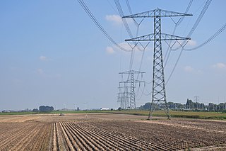
Nederlands: De Klappolder (noordelijk deel) ligt in de gemeente Lansingerland tussen tussen Zoetermeer, Moerkapelle en Bleiswijk. Rechts de A12. De voorste hoogspanningsmast is mast KIJ-BWK-380-42, die sinds 2010 is voorzien van V-ophanging wegens een kleine hoek die toen in het traject ontstond bij trajectaanpassing. Het is nu een hoekdraagmast.
Deutsch: Der Klappolder (nördlicher Teil) befindet sich in der Gemeinde Lansingerland zwischen Zoetermeer, Moerkapelle und Bleiswijk. Auf der rechten Seite befindet sich die Autobahn A12. Bei dem vorderen Mast handelt es sich um den Mast KIJ-BWK-380-42, der seit 2010 mit einer V-Aufhängung ausgestattet ist, da im Zuge der Streckenänderung ein kleiner Winkel in der Strecke entstanden ist. Es ist jetzt ein Winkeltragmast.
English: The 'Klap Polder' lies between Zoetermeer, Moerkapelle en Bleiswijk (Municipality Lansingerland, Province South Holland, Netherlands). |
| Date | |
| Source | Own work |
| Author | Vincent van Zeijst |
Looking to the East from:
| Camera location | | View this and other nearby images on: OpenStreetMap |
|---|
Licensing
[edit]
This file is licensed under the Creative Commons Attribution-Share Alike 3.0 Unported license.
- You are free:
- to share – to copy, distribute and transmit the work
- to remix – to adapt the work
- Under the following conditions:
- attribution – You must give appropriate credit, provide a link to the license, and indicate if changes were made. You may do so in any reasonable manner, but not in any way that suggests the licensor endorses you or your use.
- share alike – If you remix, transform, or build upon the material, you must distribute your contributions under the same or compatible license as the original.
File history
Click on a date/time to view the file as it appeared at that time.
| Date/Time | Thumbnail | Dimensions | User | Comment | |
|---|---|---|---|---|---|
| current | 20:18, 1 October 2014 | | 2,144 × 1,424 (763 KB) | Loranchet (talk | contribs) | {{Information |Description ={{nl|1=De Klappolder (noordelijk deel) ligt in de gemeente Lansingerland tussen tussen Zoetermeer, Moerkapelle en Bleiswijk. Rechts de A12.}} {{en|1=The 'Klap Polder' lies between Zoetermeer, Moerkapelle en Bleiswijk (Mun... |
You cannot overwrite this file.
File usage on Commons
There are no pages that use this file.
File usage on other wikis
The following other wikis use this file:
- Usage on nl.wikipedia.org
- Usage on pt.wikipedia.org
- Usage on www.wikidata.org