File:Netherlands, Hoogheemraadschap Rijnland, Wassenaar - Stompwijk, map of 1746.jpg
Jump to navigation
Jump to search

Size of this preview: 790 × 599 pixels. Other resolutions: 316 × 240 pixels | 633 × 480 pixels | 1,012 × 768 pixels | 1,280 × 971 pixels | 2,560 × 1,942 pixels | 4,112 × 3,120 pixels.
Original file (4,112 × 3,120 pixels, file size: 5.48 MB, MIME type: image/jpeg)
Captions
Captions
Add a one-line explanation of what this file represents
Summary
[edit]| Description |
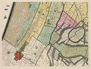
Nederlands: Kaart uit 1746 van het Hoogheemraadschap van Rijnland, deelgebied Wassenaar - Den Haag - Stompwijk - Zoeterwoude. Deze kaart is de derde uitgave van de overzichtskaart van 1647, vervaardigd door de landmeters Jan Janszoon (Johannes) Douw en Steven Pieterszoon van Brouckhuijsen. De tweede uitgave, herzien door Johan Douw, werd uitgegeven in 1687. Deze derde uitgave uit 1746 is ingrijpend herzien door landmeter Melchior Bolstra. De wijzigingen hebben vooral betrekking op het in kaart brengen van uitgestrekte veenplassen en reeds drooggemaakte veenplassen. Deze plassen zijn ontstaan vanaf 1530 toen men bij de turfwinning overging van delven op baggeren. Afkomstig uit de collectie kartografische documenten van het Hoogheemraadschap van Rijnland, collectienummer A-4493. Kopergravure : gekleurd; 45,5 x 55,5 cm, schaal ca. 1 : 28.000
English: Map from 1746 of the Water Board of Rhineland, area Wassenaar - The Hague - Stompwijk - Zoeterwoude (Province of North Holland, Netherlands). This map is the third edition of the map of 1647, made by the surveyors Jan Janszoon (Johannes) Douw and Steven Pieterszoon van Brouckhuijsen. A second edition, revised by Johan Douw, was published in 1687. This third edition from 1746 has been substantially revised by surveyor Melchior Bolstra. The changes concern mainly the identification of vast peat bogs and reclaimed peat lakes. These lakes were created from 1530 when people passed from peat mining to peat dredging, resulting in vast areas below sea level. This map comes from the cartographic collection of the Water Board of Rhineland ('Hoogheemraadschap van Rijnland'), collection number A-4493. |
| Date | |
| Source | http://watwaswaar.nl/#Ke-Qq-3-1-1v-1-2V2O-26b2---lCa |
| Author | Melchior Bolstra |
| Permission (Reusing this file) |
The website from which this image was taken (see: original source) does not provide any copyright information, but this image from 1746 is clearly in the public domain. [In the Netherlands copyright expires 70 years after the death of the author or 70 years after first publication in the case of anonymous or pseudonymous works or works published by a legal entity]. [Het auteursrecht in Nederland vervalt 70 jaar na de dood van de auteur of 70 jaar na de eerste openbaarmaking van het werk, indien het gaat om een anoniem of om een onder pseudoniem verschenen werk of werk van een rechtspersoon]. |
| Other versions |
.jpg)
For orientation purposes: the center of the egg-shaped polder on the right side of this map is located at:
| Camera location | | View this and other nearby images on: OpenStreetMap |
|---|
Licensing
[edit]
|
This work is in the public domain in its country of origin and other countries and areas where the copyright term is the author's life plus 100 years or fewer. | |
| This file has been identified as being free of known restrictions under copyright law, including all related and neighboring rights. | |
File history
Click on a date/time to view the file as it appeared at that time.
| Date/Time | Thumbnail | Dimensions | User | Comment | |
|---|---|---|---|---|---|
| current | 20:40, 15 October 2012 | | 4,112 × 3,120 (5.48 MB) | Loranchet (talk | contribs) | {{Information |Description ={{nl|1=Nederlands: Kaart uit 1746 van het Hoogheemraadschap van Rijnland, deelgebied Wassenaar - Den Haag - Stompwijk - Zoeterwoude. Deze kaart is de derde uitgave van de overzichtskaart van 1647, vervaardigd door de land... |
You cannot overwrite this file.
File usage on Commons
The following page uses this file:
Categories:
- Maps of Stompwijk
- Maps of Zoeterwoude
- Old maps of The Hague
- Maps of Wassenaar
- Maps of Leidschendam-Voorburg
- Old maps of South Holland
- Hoogheemraadschap van Rijnland
- 1746 in the Netherlands
- Maps of polders in South Holland
- Maps of Voorschoten
- The Hague in the 1740s
- Melchior Bolstra
- Voorschoten in the 18th century
- Zoeterwoude in the 18th century