File:Nepean Ontario locator map.png
Jump to navigation
Jump to search
No higher resolution available.
Nepean_Ontario_locator_map.png (357 × 297 pixels, file size: 7 KB, MIME type: image/png)
Captions
Captions
Add a one-line explanation of what this file represents
| Description |
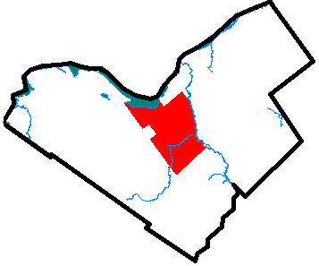
Locator map of Nepean, Ontario, a suburb of Ottawa, Ontario. This map is showing the extent of Nepean within what is now the City of Ottawa c. 2000. |
| Date | circa 2000 |
| Source | Uploaded as en:Image:Nepean.PNG on November 16 2004. |
| Creator | |
| Permission (Reusing this file) |
PD |
| Georeferencing | If inappropriate please set warp_status = skip to hide. |
| |
This work has been released into the public domain by its author, Earl Andrew, at the English Wikipedia project. This applies worldwide. In case this is not legally possible: |
File history
Click on a date/time to view the file as it appeared at that time.
| Date/Time | Thumbnail | Dimensions | User | Comment | |
|---|---|---|---|---|---|
| current | 19:54, 19 August 2006 | | 357 × 297 (7 KB) | Jkelly (talk | contribs) | {{Information |Description=Locator map of Nepean, Ontario, a suburb of Ottawa, Ontario. |Source=Uploaded as en:Image:Nepean.PNG on November 16 2004. |Date=November 16 2004 |Author=en:User:Earl Andrew |Permission=PD }} { |
You cannot overwrite this file.
File usage on Commons
The following page uses this file:
File usage on other wikis
The following other wikis use this file:
- Usage on en.wikipedia.org
- Usage on fa.wikipedia.org
- Usage on it.wikipedia.org
- Usage on ru.wikipedia.org
- Usage on www.wikidata.org