File:Nepal - Sagamartha Trek - Ngozumba Gl from Gokyo Ri.jpg

Original file (7,497 × 1,863 pixels, file size: 3.06 MB, MIME type: image/jpeg)
Captions
Captions
Summary
[edit]
| Description |
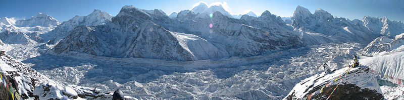
The sweep of the Ngozumba glacier (Nepal's longest) and encircling mountains clad in new snow as seen from Gokyo Ri just after sunrise. The sun rose just behind Everest (centre, left peak) and Nuptse/Lhotse (centre, right peaks). All the peaks are above 6000m. Main peaks visible (L to R) include (I think) Chakung (7029); Chunbu (6859); Cholo (6059), the closest at left of centre; Lobuche West (6145) and East (6119), centre; Everest, Nuptse and Lhotse tallest behind and above; Arakam Tse (5904); Cholatse (6440); and Taboche (6501). (if I've got them wrong, let me know...) You can see the 3rd Gokyo Lake at the bottom right |
| Date | |
| Source | Nepal - Sagamartha Trek - Ngozumba Gl from Gokyo Ri |
| Author | McKay Savage from Chennai, India |
| Camera location | | View this and other nearby images on: OpenStreetMap |
|---|
Licensing
[edit]
- You are free:
- to share – to copy, distribute and transmit the work
- to remix – to adapt the work
- Under the following conditions:
- attribution – You must give appropriate credit, provide a link to the license, and indicate if changes were made. You may do so in any reasonable manner, but not in any way that suggests the licensor endorses you or your use.
| This image was originally posted to Flickr by mckaysavage at https://www.flickr.com/photos/56796376@N00/493506926. It was reviewed on 1 May 2009 by FlickreviewR and was confirmed to be licensed under the terms of the cc-by-2.0. |
| Annotations | This image is annotated: View the annotations at Commons |
File history
Click on a date/time to view the file as it appeared at that time.
| Date/Time | Thumbnail | Dimensions | User | Comment | |
|---|---|---|---|---|---|
| current | 13:55, 4 December 2009 | 7,497 × 1,863 (3.06 MB) | Rupert Pupkin (talk | contribs) | bigger version | |
| 23:46, 30 April 2009 | 1,024 × 254 (199 KB) | Gemini1980 (talk | contribs) | {{Information |Description= The sweep of the Ngozumba glacier (Nepal's longest) and encircling mountains clad in new snow as seen from Gokyo Ri just after sunrise. The sun rose just behind Everest (centre, left peak) and Nuptse/Lhotse (centre, right pea |
You cannot overwrite this file.
File usage on Commons
The following page uses this file:
File usage on other wikis
The following other wikis use this file:
- Usage on de.wikipedia.org
- Usage on en.wikipedia.org
- Usage on es.wikipedia.org
- Usage on fr.wikipedia.org
- Usage on hr.wikipedia.org
- Usage on sh.wikipedia.org
- Usage on www.wikidata.org
- Usage on zh.wikipedia.org