File:Nejzápadnější bod Česka.jpg
Jump to navigation
Jump to search

Size of this preview: 680 × 600 pixels. Other resolutions: 272 × 240 pixels | 544 × 480 pixels | 871 × 768 pixels | 1,161 × 1,024 pixels | 2,129 × 1,878 pixels.
Original file (2,129 × 1,878 pixels, file size: 5.57 MB, MIME type: image/jpeg)
Captions
Captions
Add a one-line explanation of what this file represents
Summary
[edit]
| Description |
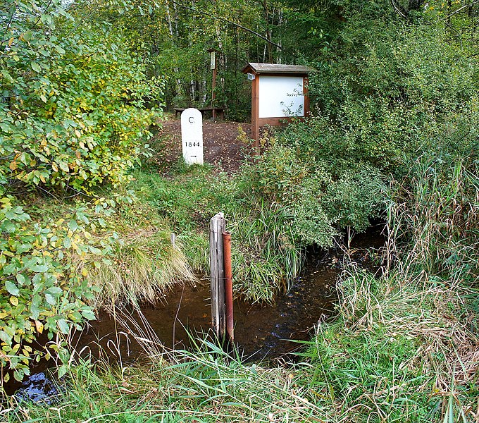
Čeština: Nejzápadnější bod Česka.
English: Westernmost point of Czechia.
Français : Le point le plus ouest de la Tchèquie.
Русский: Самая западная точка Чехии. |
| Date | |
| Source | Own work. |
| Author | Ondřej Žváček |
| Permission (Reusing this file) |
Čeština: Můžete tento soubor šířit a upravovat, pokud budete uvádět autora (viz níže).
English: Free to distribute and modify as long as the author is attributed (see below).
فارسی: آزاد برای نشر و ویرایش تا زمانی که اثر به پدیدآورنده نسبت داده شود (پایین را ببینید).
Français : Libre de distribuer et de modifier tant que l'auteur est indiqué (voir dessous).
Русский: Можно размещать и делать производные работы при условии, что указан автор (смотри ниже). |
| Camera location | | View this and other nearby images on: OpenStreetMap |
|---|
Licensing
[edit]
I, Ondřej Žváček, the copyright holder of this work, hereby publishes it under the following licenses:

|
Permission is granted to copy, distribute and/or modify this document under the terms of the GNU Free Documentation License, Version 1.2 or any later version published by the Free Software Foundation; with no Invariant Sections, no Front-Cover Texts, and no Back-Cover Texts. A copy of the license is included in the section entitled GNU Free Documentation License. |
| This file is licensed under the Creative Commons Attribution-Share Alike 3.0 Unported license. | ||
| Attribution: I, Ondřej Žváček | ||
| ||
| This licensing tag was added to this file as part of the GFDL licensing update. |
This file is licensed under the Creative Commons Attribution 2.5 Generic license.
Attribution: I, Ondřej Žváček
- You are free:
- to share – to copy, distribute and transmit the work
- to remix – to adapt the work
- Under the following conditions:
- attribution – You must give appropriate credit, provide a link to the license, and indicate if changes were made. You may do so in any reasonable manner, but not in any way that suggests the licensor endorses you or your use.
You may select the license of your choice.
| Annotations | This image is annotated: View the annotations at Commons |
File history
Click on a date/time to view the file as it appeared at that time.
| Date/Time | Thumbnail | Dimensions | User | Comment | |
|---|---|---|---|---|---|
| current | 18:57, 1 October 2012 | | 2,129 × 1,878 (5.57 MB) | Ondřej Žváček (talk | contribs) | {{Information |Description= {{cs|Nejzápadnější bod Česka.}} {{en|Westernmost point of Czechia.}} {{fr|Le point le plus ouest de la Tchèquie.}} {{ru|Самая западная точка [[:ru:Че... |
You cannot overwrite this file.
File usage on Commons
The following page uses this file:
File usage on other wikis
The following other wikis use this file:
- Usage on cs.wikipedia.org
- Usage on en.wikipedia.org
- Usage on eo.wikipedia.org
- Usage on pt.wikipedia.org
- Usage on uk.wikipedia.org