File:Neic ptad w - Magnitude 4.9 - BEIJING-HEBEI BORDER REGION, CHINA.jpg
Jump to navigation
Jump to search
No higher resolution available.
Neic_ptad_w_-_Magnitude_4.9_-_BEIJING-HEBEI_BORDER_REGION,_CHINA.jpg (517 × 557 pixels, file size: 55 KB, MIME type: image/jpeg)
Captions
Captions
Add a one-line explanation of what this file represents
Major Tectonic Boundaries: Subduction Zones -purple, Ridges -red and Transform Faults -green
| Description |
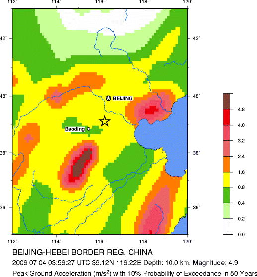
Seismic Hazard Map Magnitude 4.9 BEIJING-HEBEI BORDER REG, CHINA Tuesday, July 04, 2006 at 03:56:27 UTC |
|||
| Date | July 04, 2006 at 03:56:27 UTC | |||
| Source | http://neic.usgs.gov/neis/bulletin/neic_ptad_w.html | |||
| Author | USGS | |||
| Permission (Reusing this file) |
|
File history
Click on a date/time to view the file as it appeared at that time.
| Date/Time | Thumbnail | Dimensions | User | Comment | |
|---|---|---|---|---|---|
| current | 07:18, 4 July 2006 | | 517 × 557 (55 KB) | Shizhao (talk | contribs) | Major Tectonic Boundaries: Subduction Zones -purple, Ridges -red and Transform Faults -green {{Information |Description=Seismic Hazard Map Magnitude 4.9 BEIJING-HEBEI BORDER REG, CHINA Tuesday, July 04, 2006 at 03:56:27 UTC |Source=http://neic.usgs.gov/ |
You cannot overwrite this file.
File usage on Commons
There are no pages that use this file.
File usage on other wikis
The following other wikis use this file:
- Usage on nl.wikibooks.org
- Usage on zh.wikinews.org