File:Nebelmeer Mittelland.jpg
Jump to navigation
Jump to search
No higher resolution available.
Nebelmeer_Mittelland.jpg (590 × 399 pixels, file size: 47 KB, MIME type: image/jpeg)
Captions
Captions
Add a one-line explanation of what this file represents
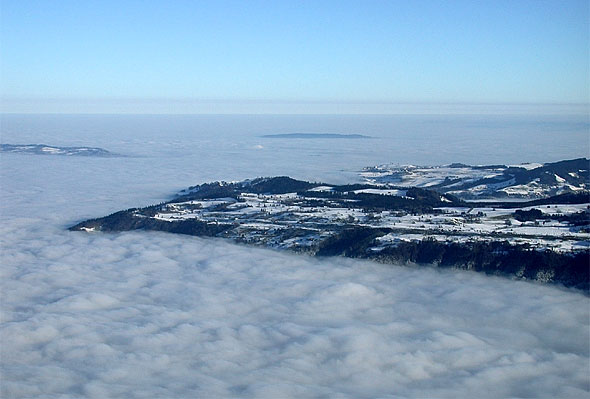
English: Northnortheastern view from Mt. Rigi on the sea of fog (upper limit about 800 meters AMSL) that covers the Swiss plateau. In the foreground the Zugerberg, in the left the Albis range, in the background the Pfannenstiel.
Deutsch: Blick vom Rigi nach Nordnordosten auf das Nebelmeer (Obergrenze bei rund 800 m ü. M.) über dem Mittelland. Im Vordergrund der Zugerberg, links die Höhe der Albiskette, im Hintergrund der Pfannenstiel.
This file was provided to Wikimedia Commons by Roland Zumbühl of Picswiss as part of a cooperation project. If the direct link to the picture is not provided (URLs are subject to changes), you can find the picture starting from the canton of the subject: http://www.picswiss.ch/geo.html then the location.
|

|
Permission is granted to copy, distribute and/or modify this document under the terms of the GNU Free Documentation License, Version 1.2 or any later version published by the Free Software Foundation; with no Invariant Sections, no Front-Cover Texts, and no Back-Cover Texts. A copy of the license is included in the section entitled GNU Free Documentation License. |
| This file is licensed under the Creative Commons Attribution-Share Alike 3.0 Unported license. | ||
| ||
| This licensing tag was added to this file as part of the GFDL licensing update. |
File history
Click on a date/time to view the file as it appeared at that time.
| Date/Time | Thumbnail | Dimensions | User | Comment | |
|---|---|---|---|---|---|
| current | 18:34, 25 July 2005 | | 590 × 399 (47 KB) | J. 'mach' wust (talk | contribs) | Northnortheastern view from the Rigi on the sea of fog (upper limit about 800 metters AMSL) that covers the Swiss plateau. In the foreground the Zugerberg, in the left the Albis range, in the background the Pfannenstiel. {{Bild-Picswiss}} |
You cannot overwrite this file.
File usage on Commons
The following page uses this file:
File usage on other wikis
The following other wikis use this file:
- Usage on af.wikipedia.org
- Usage on de.wikipedia.org
- Usage on en.wikipedia.org
- Usage on eo.wikipedia.org
- Usage on et.wikipedia.org
- Usage on la.wikipedia.org
- Usage on nl.wikipedia.org
- Usage on ru.wikipedia.org
- Usage on sl.wikipedia.org