File:Neasden metropolitan line station geograph-2384536-by-Ben-Brooksbank.jpg
Jump to navigation
Jump to search

Size of this preview: 800 × 484 pixels. Other resolutions: 320 × 193 pixels | 640 × 387 pixels | 1,024 × 619 pixels | 1,280 × 774 pixels | 2,394 × 1,447 pixels.
Original file (2,394 × 1,447 pixels, file size: 993 KB, MIME type: image/jpeg)
Captions
Captions
Add a one-line explanation of what this file represents
Summary
[edit]
| Description |
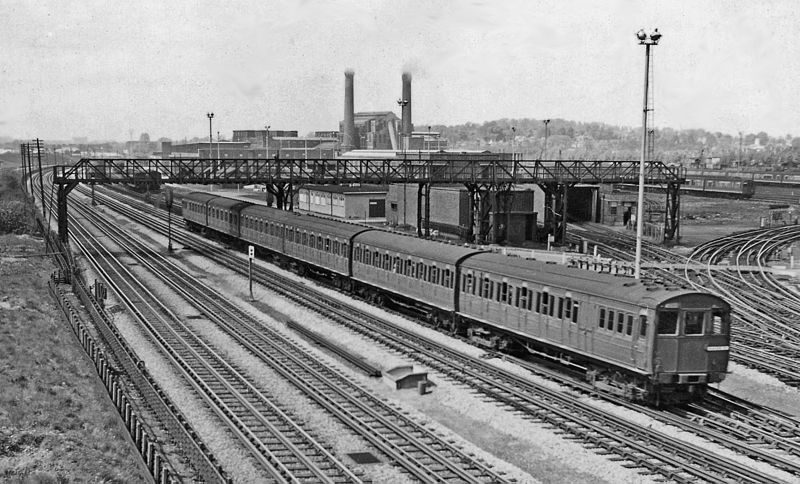
English: Up London Transport Metropolitan Line electric train at Neasden. View NW from North Circular Road bridge, towards Harrow-on-the-Hill, Uxbridge, Rickmansworth, Watford, Amersham and Aylesbury, on the LPTB Metropolitan line from Baker Street and the City. The train Series T compartment stock and will have come from Uxbridge or Watford. Behind it is the Neasden (Metropolitan) Works and Depot. Off to the left is the ex-GC line from Marylebone to Northolt Junction, High Wycombe and Princes Risborough. |
| Date | Taken on 2 May 1959 |
| Source | From geograph.org.uk |
| Author | Ben Brooksbank |
| Permission (Reusing this file) |
Creative Commons Attribution Share-alike license 2.0 |
| Attribution (required by the license) | Ben Brooksbank / Up London Transport Metropolitan Line electric train at Neasden / |
| Camera location | | View this and other nearby images on: OpenStreetMap |
|---|
Licensing
[edit]

|
This image was taken from the Geograph project collection. See this photograph's page on the Geograph website for the photographer's contact details. The copyright on this image is owned by Ben Brooksbank and is licensed for reuse under the Creative Commons Attribution-ShareAlike 2.0 license.
|
This file is licensed under the Creative Commons Attribution-Share Alike 2.0 Generic license.
Attribution: Ben Brooksbank
- You are free:
- to share – to copy, distribute and transmit the work
- to remix – to adapt the work
- Under the following conditions:
- attribution – You must give appropriate credit, provide a link to the license, and indicate if changes were made. You may do so in any reasonable manner, but not in any way that suggests the licensor endorses you or your use.
- share alike – If you remix, transform, or build upon the material, you must distribute your contributions under the same or compatible license as the original.
File history
Click on a date/time to view the file as it appeared at that time.
| Date/Time | Thumbnail | Dimensions | User | Comment | |
|---|---|---|---|---|---|
| current | 19:29, 12 May 2011 | | 2,394 × 1,447 (993 KB) | Chevin (talk | contribs) | == {{int:filedesc}} == {{Information |Description={{en|1=Up London Transport Metropolitan Line electric train at Neasden View NW from North Circular Road bridge, towards Harrow-on-the-Hill, Uxbridge, Rickmansworth, Watford, Amersham and Aylesbury, on the |
You cannot overwrite this file.
File usage on Commons
The following page uses this file:
File usage on other wikis
The following other wikis use this file:
- Usage on da.wikipedia.org
- Usage on de.wikipedia.org
- Usage on en.wikipedia.org
- Usage on es.wikipedia.org
- Usage on it.wikipedia.org
- Usage on ja.wikipedia.org