File:Near Little Cherry Creek - Flickr - aspidoscelis.jpg
Jump to navigation
Jump to search

Size of this preview: 800 × 533 pixels. Other resolutions: 320 × 213 pixels | 640 × 427 pixels | 1,024 × 683 pixels | 1,280 × 853 pixels | 2,560 × 1,707 pixels | 3,600 × 2,400 pixels.
Original file (3,600 × 2,400 pixels, file size: 4.29 MB, MIME type: image/jpeg)
Captions
Captions
Add a one-line explanation of what this file represents
Summary
[edit]
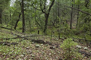
| Description | South side of the Pinos Altos Range, below the Continental Divide Trail along Little Cherry Creek, 32.89884 -108.19045, Grant County, New Mexico, 19 Aug 2017. Cymopterus lemmonii, Achillea millefolium, Antennaria marginata, Brickellia grandiflora, Erigeron, Hymenoxys hoopesii, Leibnitzia lyrata, Packera neomexicana, Symphoricarpos rotundifolius, Commelina dianthifolia, Juniperus deppeana, Woodsia phillipsii, Monotropa hypopitys, Astragalus cobrensis, Lathyrus arizonicus, Phaseolus parvulus, Robinia neomexicana, Vicia americana, Quercus gambelii, Frasera speciosa, Geranium caespitosum, Agastache pallidiflora, Linum neomexicanum, Malaxis soulei, Platanthera brevifolia, Oxalis metcalfei, Pinus ponderosa, Pseudotsuga menziesii, Bromus ciliatus, Koeleria macrantha, Delphinium scopulorum, Fragaria vesca, Prunus serotina, etc. |
| Date | |
| Source | Near Little Cherry Creek |
| Author | Patrick Alexander from Las Cruces, NM |
| Camera location | | View this and other nearby images on: OpenStreetMap |
|---|
Licensing
[edit]
| This file is made available under the Creative Commons CC0 1.0 Universal Public Domain Dedication. | |
| The person who associated a work with this deed has dedicated the work to the public domain by waiving all of their rights to the work worldwide under copyright law, including all related and neighboring rights, to the extent allowed by law. You can copy, modify, distribute and perform the work, even for commercial purposes, all without asking permission.
|
| This image was originally posted to Flickr by aspidoscelis at https://flickr.com/photos/26246711@N00/37977368341. It was reviewed on 3 October 2020 by FlickreviewR 2 and was confirmed to be licensed under the terms of the cc-zero. |
File history
Click on a date/time to view the file as it appeared at that time.
| Date/Time | Thumbnail | Dimensions | User | Comment | |
|---|---|---|---|---|---|
| current | 14:28, 3 October 2020 | | 3,600 × 2,400 (4.29 MB) | Josve05a (talk | contribs) | == {{int:filedesc}} == =={{int:filedesc}}== {{Information |Description=South side of the Pinos Altos Range, below the Continental Divide Trail along Little Cherry Creek, 32.89884 -108.19045, Grant County, New Mexico, 19 Aug 2017. ''Cymopterus lemmonii, Achillea millefolium, Antennaria marginata, Brickellia grandiflora, Erigeron, Hymenoxys hoopesii, Leibnitzia lyrata, Packera neomexicana, Symphoricarpos rotundifolius, Commelina dianthifolia, Juniperus deppeana, Woodsia phillipsii, Monotropa hy... |
You cannot overwrite this file.
File usage on Commons
There are no pages that use this file.