File:Naval Gun Mount - geograph.org.uk - 819177.jpg
Jump to navigation
Jump to search
Size of this preview: 400 × 600 pixels. Other resolutions: 160 × 240 pixels | 427 × 640 pixels.
Original file (427 × 640 pixels, file size: 197 KB, MIME type: image/jpeg)
Captions
Captions
Add a one-line explanation of what this file represents
Summary
[edit]
| Description |
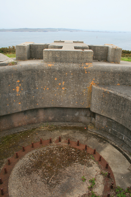
English: Naval Gun Mount At the turn of the twentieth century the Royal Navy had plans to make the Isles of Scilly the site of its main North Atlantic base.
Booms were to be constructed between various of the out-lying rocks and this battery was constructed to defend the anchorage in The Road. The growing use of the Dreadnought style of battleship put paid to this plan as the entrances to the islands though the North West Passage and St Mary's Sound (the body of water seen in this picture) are not deep enough to accommodate the draught of those vessels. The plan was changed and Scapa Flow used instead. |
| Date | |
| Source | From geograph.org.uk |
| Author | David Lally |
| Attribution (required by the license) | David Lally / Naval Gun Mount / |
| Camera location | | View this and other nearby images on: OpenStreetMap |
|---|
_heading:225.00&language=en)
| Object location | | View this and other nearby images on: OpenStreetMap |
|---|
_heading:225.00&language=en)
Licensing
[edit]

|
This image was taken from the Geograph project collection. See this photograph's page on the Geograph website for the photographer's contact details. The copyright on this image is owned by David Lally and is licensed for reuse under the Creative Commons Attribution-ShareAlike 2.0 license.
|
This file is licensed under the Creative Commons Attribution-Share Alike 2.0 Generic license.
Attribution: David Lally
- You are free:
- to share – to copy, distribute and transmit the work
- to remix – to adapt the work
- Under the following conditions:
- attribution – You must give appropriate credit, provide a link to the license, and indicate if changes were made. You may do so in any reasonable manner, but not in any way that suggests the licensor endorses you or your use.
- share alike – If you remix, transform, or build upon the material, you must distribute your contributions under the same or compatible license as the original.
File history
Click on a date/time to view the file as it appeared at that time.
| Date/Time | Thumbnail | Dimensions | User | Comment | |
|---|---|---|---|---|---|
| current | 12:41, 20 February 2011 | | 427 × 640 (197 KB) | GeographBot (talk | contribs) | == {{int:filedesc}} == {{Information |description={{en|1=Naval Gun Mount At the turn of the twentieth century the Royal Navy had plans to make the Isles of Scilly the site of its main North Atlantic base. Booms were to be constructed between various of |
You cannot overwrite this file.
File usage on Commons
There are no pages that use this file.