File:Naturraumkarte Oestliches Rhoenvorland.png
Jump to navigation
Jump to search
No higher resolution available.
Naturraumkarte_Oestliches_Rhoenvorland.png (521 × 420 pixels, file size: 376 KB, MIME type: image/png)
Captions
Captions
Add a one-line explanation of what this file represents
Summary
[edit]
| Description |
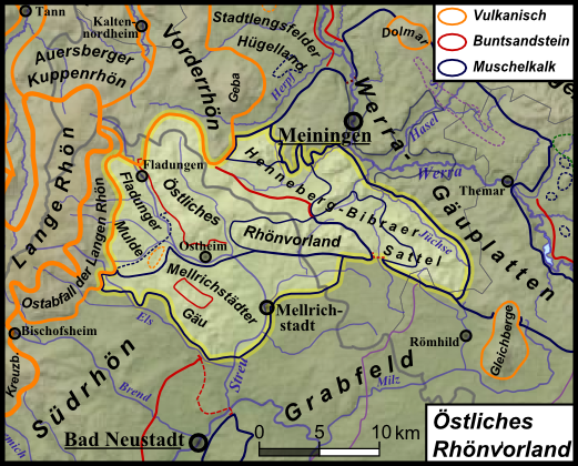
Deutsch: Naturraumkarte des Östlichen Rhönvorlandes inclisive Fladunger Mulde, Bibraer Sattel und Mellrichstädter Gäu, die gemeinsam die Muschelkalklandschaften der Werra-Gäuplatten nach Südwesten, zwischen Rhön (W) und Gleichbergen (O) fortsetzen.. |
| Date | |
| Source | Own work |
| Author |
|
| Other versions | Siehe Galerie |
Licensing
[edit]
I, the copyright holder of this work, hereby publish it under the following license:
This file is licensed under the Creative Commons Attribution 3.0 Unported license.
- You are free:
- to share – to copy, distribute and transmit the work
- to remix – to adapt the work
- Under the following conditions:
- attribution – You must give appropriate credit, provide a link to the license, and indicate if changes were made. You may do so in any reasonable manner, but not in any way that suggests the licensor endorses you or your use.
File history
Click on a date/time to view the file as it appeared at that time.
| Date/Time | Thumbnail | Dimensions | User | Comment | |
|---|---|---|---|---|---|
| current | 13:13, 13 January 2013 | | 521 × 420 (376 KB) | Elop (talk | contribs) | uaaah |
| 01:21, 13 January 2013 |  | 2,146 × 1,813 (5.59 MB) | Elop (talk | contribs) | k | |
| 23:34, 12 January 2013 |  | 521 × 420 (376 KB) | Elop (talk | contribs) | update | |
| 14:04, 11 January 2013 |  | 521 × 420 (367 KB) | Elop (talk | contribs) | Maßstab ward vergessen | |
| 00:28, 11 January 2013 |  | 521 × 420 (367 KB) | Elop (talk | contribs) | k | |
| 20:39, 10 January 2013 |  | 521 × 420 (366 KB) | Elop (talk | contribs) | Legendenanordnung, Ausschnitt, Beschriftung | |
| 18:47, 10 January 2013 |  | 510 × 371 (305 KB) | Elop (talk | contribs) | {{Information |Description={{de|1=Naturraumkarte des Östlichen Rhönvorlandes inclisive ''Fladunger Mulde'', ''Bibraer Sattel'' und ''Mellrichstädter Gäu'', die gemeinsam die Muschelkalklandschaften der [[:de:Werra-G... |
You cannot overwrite this file.
File usage on Commons
The following 2 pages use this file:
File usage on other wikis
The following other wikis use this file:
- Usage on de.wikipedia.org