File:Naturraeumliche Grossregionen Deutschlands, Erzgebirge.png
Jump to navigation
Jump to search

Size of this preview: 472 × 599 pixels. Other resolutions: 189 × 240 pixels | 378 × 480 pixels | 605 × 768 pixels | 807 × 1,024 pixels | 1,827 × 2,318 pixels.
Original file (1,827 × 2,318 pixels, file size: 5.87 MB, MIME type: image/png)
Captions
Captions
Add a one-line explanation of what this file represents
Gxuþguģhchchc
Summary
[edit]
| Description |
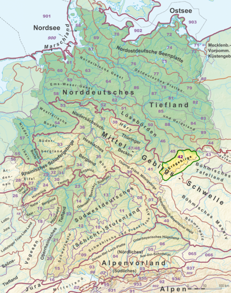
Deutsch: Das Erzgebirge (grün umrandet und in leuchtendem Farbton) auf der Karte der Naturräumlichen Großregionen Deutschlands; Großregionen 3. Ordnung nach dem Handbuch der naturräumlichen Gliederung Deutschlands. Beschreibung siehe File:Naturraeumliche Grossregionen Deutschlands plus.png. |
| Date | |
| Source |
This file was derived from: Naturraeumliche Grossregionen Deutschlands plus.png:  |
| Author |
|
| This is a retouched picture, which means that it has been digitally altered from its original version. Modifications: Highlighting of Black Forest. The original can be viewed here: Naturraeumliche Grossregionen Deutschlands plus.png:
|
Original upload log
[edit]
This image is a derivative work of the following images:
- File:Naturraeumliche_Grossregionen_Deutschlands_plus.png licensed with Cc-by-sa-3.0, GFDL
- 2012-07-02T13:46:00Z Elop 1827x2318 (6834609 Bytes) k
- 2012-07-01T21:29:38Z Elop 1827x2318 (6834241 Bytes) k
- 2012-07-01T15:08:18Z Elop 1827x2318 (6841614 Bytes) k
- 2012-06-30T22:44:08Z Elop 1827x2318 (6807023 Bytes) Update; insbesondere Alpen komplett neu; alle Pfade neu nachgezeichnet und korrigiert, auch außerhalb Dlands; NNWs Karte damit vektoriell erneuert
- 2012-05-27T14:31:58Z Elop 1827x2318 (6814849 Bytes) Update
- 2011-10-25T00:25:26Z Elop 1827x2318 (6802379 Bytes) k
- 2011-10-24T16:33:48Z Elop 1827x2319 (6646086 Bytes) Grenzkorr. Weser/Aller
- 2011-10-24T01:38:18Z Elop 1827x2318 (6558759 Bytes)
- 2011-10-23T21:56:50Z Elop 1827x2318 (6556370 Bytes) Anpassungen
- 2011-10-23T18:43:06Z Elop 1827x2318 (6786604 Bytes) == {{int:filedesc}} == {{Information |Description={{de|1=Karte der [[:de:Naturräumliche Großregionen Deutschlands|Naturräumlichen Großregionen Deutschlands]]; Großregionen 3. Ordnung nach dem [[:de:Handbuch der naturräu
Licensing
[edit]
I, the copyright holder of this work, hereby publish it under the following license:
This file is licensed under the Creative Commons Attribution-Share Alike 3.0 Unported license.
- You are free:
- to share – to copy, distribute and transmit the work
- to remix – to adapt the work
- Under the following conditions:
- attribution – You must give appropriate credit, provide a link to the license, and indicate if changes were made. You may do so in any reasonable manner, but not in any way that suggests the licensor endorses you or your use.
- share alike – If you remix, transform, or build upon the material, you must distribute your contributions under the same or compatible license as the original.
File history
Click on a date/time to view the file as it appeared at that time.
| Date/Time | Thumbnail | Dimensions | User | Comment | |
|---|---|---|---|---|---|
| current | 19:39, 27 July 2014 | | 1,827 × 2,318 (5.87 MB) | Sitacuisses (talk | contribs) | {{Information |Description ={{de|1=Das Erzgebirge (grün umrandet und in leuchtendem Farbton) auf der Karte der Naturräumlichen Großregionen Deutschlands; Großregionen 3. Ordnung nach dem [[:de:H... |
You cannot overwrite this file.
File usage on Commons
There are no pages that use this file.
File usage on other wikis
The following other wikis use this file:
- Usage on de.wikipedia.org