File:Nationalpark Jasmund Viktoriasicht 02.jpg
Jump to navigation
Jump to search
Size of this preview: 800 × 533 pixels. Other resolutions: 320 × 213 pixels | 640 × 427 pixels | 1,024 × 683 pixels | 1,280 × 853 pixels | 2,560 × 1,707 pixels | 5,472 × 3,648 pixels.
Original file (5,472 × 3,648 pixels, file size: 12.34 MB, MIME type: image/jpeg)
Captions
Captions
Add a one-line explanation of what this file represents
Summary
[edit]
| Description |
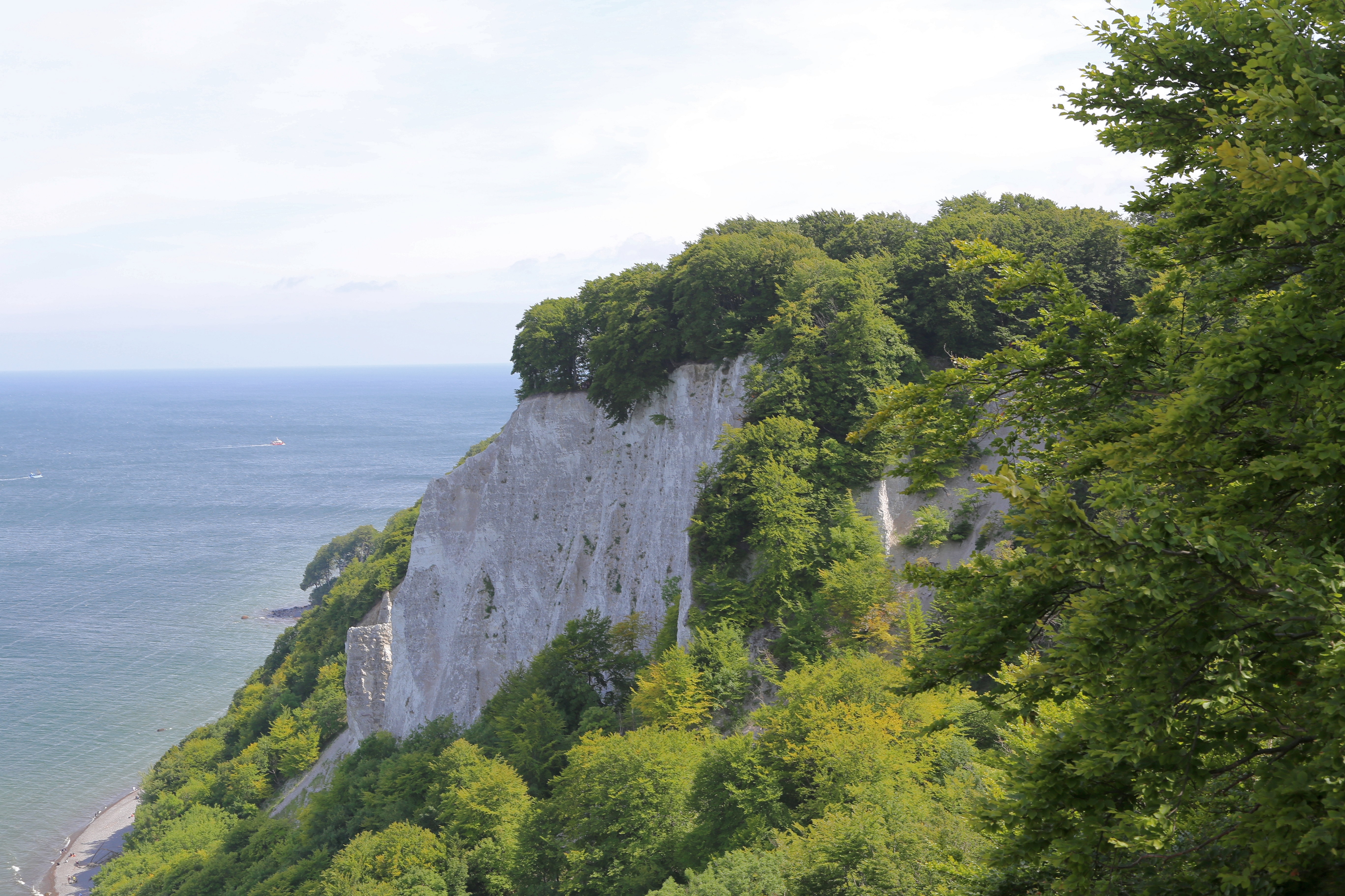
English: View from the Königsstuhl (King's Chair) to the Victoria-Sicht (Victoria Sight). This chalk cliff is situated in the Stubbenkammer, Jasmund National Park (Nationalpark Jasmund). The area belongs to Sassnitz, Landkreis Vorpommern-Rügen, Mecklenburg-Vorpommern, Germany.
Deutsch: Blick vom Königsstuhl hinüber zur Victoria-Sicht. Der Kreidefelsvorsprung ist Teil der Stubbenkammer im Nationalpark Jasmund auf der Halbinsel Jasmund. Die Felspartien befinden sich auf dem Gebiet der Stadt Sassnitz, Landkreis Vorpommern-Rügen, Mecklenburg-Vorpommern, Deutschland.
|
||||||
| Date | |||||||
| Source | Own work | ||||||
| Author | J.-H. Janßen |
| Camera location | | View this and other nearby images on: OpenStreetMap |
|---|
Notes
[edit]
This image is not public domain. Please respect the copyright protection. It may only be used according to the rules mentioned here. This specifically excludes use in social media, if applicable terms of the licenses listed here not appropriate. (See for example CC BY-SA on Facebook.) Of course, a free license is no carte blanche for use. Especially there restrictions not based on the License, for example to the personality rights of the author. This is especially true for the required attribution and the use of the image. It is expressly not allowed to give the impression through the use of the image, that the author supports the work, in which the image is used, or whose rights holders in any way. |

| Please do not upload a modified image here without consultation with the author. The author would like to make possible minor modifications only at his own source. (The source is usually a RAW file. Processing of the JPEG file means a loss of quality.) This ensures that the changes and the quality are preserved. Please if you think that any changes should be required, please contact the author. Otherwise you can upload a new image with a new name. Please use one of the templates derivative or extract. Please enter your name too, if you upload a derivative or a detail, because you're in charge of the changes. Please do not rename this file. The name is part of the attribution. In the case of misstatements, the author is pleased to provide information. |
Licensing
[edit]
This file is licensed under the Creative Commons Attribution-Share Alike 4.0 International license.
- You are free:
- to share – to copy, distribute and transmit the work
- to remix – to adapt the work
- Under the following conditions:
- attribution – You must give appropriate credit, provide a link to the license, and indicate if changes were made. You may do so in any reasonable manner, but not in any way that suggests the licensor endorses you or your use.
- share alike – If you remix, transform, or build upon the material, you must distribute your contributions under the same or compatible license as the original.
This image was uploaded as part of Wiki Loves Earth 2021.
|
 |
File history
Click on a date/time to view the file as it appeared at that time.
| Date/Time | Thumbnail | Dimensions | User | Comment | |
|---|---|---|---|---|---|
| current | 20:53, 15 May 2021 | | 5,472 × 3,648 (12.34 MB) | J.-H. Janßen (talk | contribs) | {{Information |Description ={{en|1=View from the ''Königsstuhl'' (''King's Chair'') to the ''Victoria-Sicht'' (''Victoria Sight''). This chalk cliff is situated in the ''Stubbenkammer'', Jasmund National Park (''Nationalpark Jasmund''). The area belongs to Sassnitz, Landkreis Vorpommern-Rügen, [[Mecklenburg-Vorp... |
You cannot overwrite this file.
File usage on Commons
The following page uses this file:
File usage on other wikis
The following other wikis use this file:
- Usage on de.wikipedia.org