File:Nationale 100C map-fr.png
Jump to navigation
Jump to search

Size of this preview: 524 × 600 pixels. Other resolutions: 210 × 240 pixels | 419 × 480 pixels | 1,000 × 1,145 pixels.
Original file (1,000 × 1,145 pixels, file size: 218 KB, MIME type: image/png)
Captions
Captions
Add a one-line explanation of what this file represents
| Description |
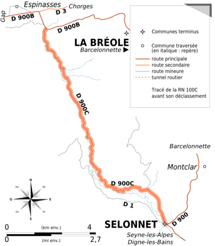
English: Map of old route nationale 100C (from 1961 to its decommission) from Selonnet to La Bréole, PACA, France.
Français : Carte de la route nationale 100C (de 1961 à son déclassement) de Selonnet à La Bréole, PACA, France. |
|||
| Date | ||||
| Source | Derived work from OpenStreetMap data | |||
| Author | OpenStreetMap contributors, adapted by Tabl-trai | |||
| Permission (Reusing this file) |
This file is licensed under the Creative Commons Attribution-Share Alike 2.0 Generic license.
|
File history
Click on a date/time to view the file as it appeared at that time.
| Date/Time | Thumbnail | Dimensions | User | Comment | |
|---|---|---|---|---|---|
| current | 13:39, 30 January 2015 | | 1,000 × 1,145 (218 KB) | Tabl-trai (talk | contribs) | {{Information |Description ={{en|1=Map of old route nationale 100C (from 1961 to its decommission) from Selonnet to La Bréole, PACA, France.}} {{fr|1=Carte de la route nationale 100C (de 1961 à son déclassement) de Selonnet à La Bréole, PACA, F... |
You cannot overwrite this file.
File usage on Commons
The following page uses this file:
File usage on other wikis
The following other wikis use this file:
- Usage on fr.wikipedia.org