File:National Mall and surrounding streets - Washington DC - 1932.jpg
Jump to navigation
Jump to search

Size of this preview: 800 × 458 pixels. Other resolutions: 320 × 183 pixels | 640 × 366 pixels | 1,068 × 611 pixels.
Original file (1,068 × 611 pixels, file size: 404 KB, MIME type: image/jpeg)
Captions
Captions
Add a one-line explanation of what this file represents
Summary
[edit]
| Description |
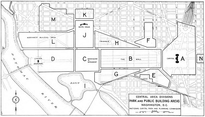
English: Map showing the National Mall and surrounding streets in downtown Washington, D.C., in the United States. The map shows the various planning zones used by the National Capital Park and Planning Commission. Note that South B Street (the future Independence Avenue SW) does not extend yet past 15th Street SW. |
| Date | |
| Source | http://hdl.handle.net/2027/uc1.$b601607?urlappend=%3Bseq=431 |
| Author | National Capital Park and Planning Commission (1932). Annual Report: National Capital Parks and Planning Commission for the Fiscal Year Ended June 30, 1932. Washington, D.C.: U.S. Government Printing Office, p. 41. |
Licensing
[edit]
This work is in the public domain in the United States because it is a work prepared by an officer or employee of the United States Government as part of that person’s official duties under the terms of Title 17, Chapter 1, Section 105 of the US Code.
Note: This only applies to original works of the Federal Government and not to the work of any individual U.S. state, territory, commonwealth, county, municipality, or any other subdivision. This template also does not apply to postage stamp designs published by the United States Postal Service since 1978. (See § 313.6(C)(1) of Compendium of U.S. Copyright Office Practices). It also does not apply to certain US coins; see The US Mint Terms of Use.
|
 | |
| This file has been identified as being free of known restrictions under copyright law, including all related and neighboring rights. | ||
File history
Click on a date/time to view the file as it appeared at that time.
| Date/Time | Thumbnail | Dimensions | User | Comment | |
|---|---|---|---|---|---|
| current | 00:42, 13 May 2014 | | 1,068 × 611 (404 KB) | Tim1965 (talk | contribs) | {{Information |Description ={{en|1=Map showing the National Mall and surrounding streets in downtown Washington, D.C., in the United States. The map shows the various planning zones used by the National Capital Park and Planning Commission. Note t... |
You cannot overwrite this file.
File usage on Commons
There are no pages that use this file.
File usage on other wikis
The following other wikis use this file:
- Usage on en.wikipedia.org