File:Nansen Fram Map-no.svg
Jump to navigation
Jump to search

Size of this PNG preview of this SVG file: 800 × 479 pixels. Other resolutions: 320 × 192 pixels | 640 × 383 pixels | 1,024 × 614 pixels | 1,280 × 767 pixels | 2,560 × 1,534 pixels | 1,003 × 601 pixels.
Original file (SVG file, nominally 1,003 × 601 pixels, file size: 175 KB)
Captions
Captions
Add a one-line explanation of what this file represents
| Description |
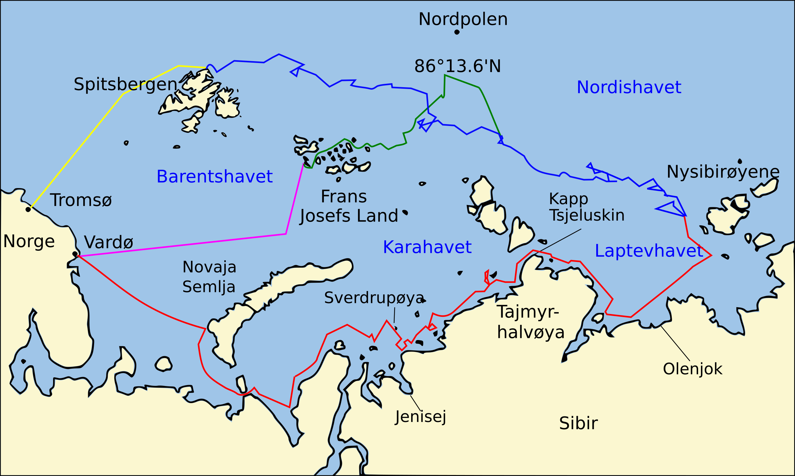
Norsk bokmål: Ruter tatt i løpet av Fram-ekspedisjonen 1893–96: «Frams» rute østover fra Vardø langs den sibirske kysten, svinger nordover ved Nysibirøyene for å entre pakkisen, juli–september 1893 «Frams» driving i isen fra Nysibirøyene nord og vest for Spitsbergen, september1893 – august 1896 Nansen og Johansens marsj til Farthes North ved 86 ° 13,6 'N, og senere tilbakereise til Northbrookøya i Frans Josef Land, mars 1895 – juni 1896 Nansen og Johansens retur til Vardø fra Northbrookøya, august 1896 «Frams» reise fra Spitsbergen til Tromsø, august 1896 |
| Date | |
| Source | Basiskart over Europas og Asias fastland fra File:Map of Russian Subjects old.png av User:fremantleboy , kart over Spitsbergen (Svalbard) er basert på File:Bjornoya map.png av User:NormanEinstein. Reiserutene er basert på dette kartet fra The Northern Lights Route. Først publisert i boken Farthest North av Fridtjof Nansen, utgitt på Constable & Co, i London 1897 |
| Author | Cocu |
| Other versions | Nansen Fram Map.svg |
| This is a retouched picture, which means that it has been digitally altered from its original version. The original can be viewed here: Nansen Fram Map.svg:
|
I, the copyright holder of this work, hereby publish it under the following licenses:
This file is licensed under the Creative Commons Attribution-Share Alike 3.0 Unported license.
- You are free:
- to share – to copy, distribute and transmit the work
- to remix – to adapt the work
- Under the following conditions:
- attribution – You must give appropriate credit, provide a link to the license, and indicate if changes were made. You may do so in any reasonable manner, but not in any way that suggests the licensor endorses you or your use.
- share alike – If you remix, transform, or build upon the material, you must distribute your contributions under the same or compatible license as the original.

|
Permission is granted to copy, distribute and/or modify this document under the terms of the GNU Free Documentation License, Version 1.2 or any later version published by the Free Software Foundation; with no Invariant Sections, no Front-Cover Texts, and no Back-Cover Texts. A copy of the license is included in the section entitled GNU Free Documentation License. |
You may select the license of your choice.
File history
Click on a date/time to view the file as it appeared at that time.
| Date/Time | Thumbnail | Dimensions | User | Comment | |
|---|---|---|---|---|---|
| current | 16:59, 13 June 2010 | | 1,003 × 601 (175 KB) | Cocu (talk | contribs) | Typo in the text in the image |
| 01:22, 13 June 2010 |  | 1,003 × 601 (175 KB) | Cocu (talk | contribs) | {{Information |Description= {{no|Ruter tatt i løpet av Fram-ekspedisjonen 1893–96: {{legend|red|«Frams» rute østover fra Vardø langs den sibirske kysten, svinger nordover ved Nysibirøyene for å entre pakkisen, juli–september 1893}}{{leg |
You cannot overwrite this file.
File usage on Commons
There are no pages that use this file.
File usage on other wikis
The following other wikis use this file:
- Usage on da.wikipedia.org
- Usage on nn.wikipedia.org
- Usage on no.wikipedia.org