File:Namiwake Shrine and the inundation area of the 2011 tsunami.jpg
Jump to navigation
Jump to search

No higher resolution available.
Namiwake_Shrine_and_the_inundation_area_of_the_2011_tsunami.jpg (750 × 273 pixels, file size: 56 KB, MIME type: image/jpeg)
Captions
Captions
Add a one-line explanation of what this file represents
Summary
[edit]
| Description |
English: Source: Anawat Suppasri, Nobuo Shuto, Fumihiko Imamura, Shunichi Koshimura, Erick Mas, Ahmet Cevdet Yalciner: "Lessons Learned from the 2011 Great East Japan Tsunami: Performance of Tsunami Countermeasures, Coastal Buildings, and Tsunami Evacuation in Japan", Pure and Applied Geophysics, 170, 6-8, (2013), pp. 993–1018, DOI: https://doi.org/10.1007/s00024-012-0511-7, online published on 7 July 2012, here: p. 1015, Figure 32 ("Namiwake Shrine and the inundation area of the 2011 tsunami"), License: Creative Commons Attribution 2.0 Generic (CC BY 2.0). URL of the image file: https://media.springernature.com/original/springer-static/image/art%3A10.1007%2Fs00024-012-0511-7/MediaObjects/24_2012_511_Fig32_HTML.jpg.
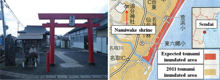
Caption as given in the above cited source: "Figure 32 - Namiwake Shrine and the inundation area of the 2011 tsunami" Context as given in the above cited source: "Tsunami memorials, for example stone monuments, can be found in many areas along the Sanriku coast. These memorials can be found in Minami-Sanriku town, where there are monuments for the 1896 Meiji, 1933 Showa, and 1960 Chile tsunamis. The message on the stone monument for the 1933 Showa tsunami (Fig. 31, left) reads “to be cautious of an abnormal receding wave”. However, these monuments, including a 2.6 m high monument for the 1960 Chile tsunami (Fig. 31, right), were destroyed by the 2011 Tohoku tsunami. The Namiwake shrine (Fig. 32, left) is a monument in the Sendai area that is located ~5.5 km from the sea (Fig. 32, right). The shrine is located in a low-lying area in the Wakabayashi ward of Sendai city, and was originally built in 1703. Many flood and tsunami disasters have occurred in this area in the past. In the 1611 Keicho event, the tsunami inundated the shrine’s original site, and ~1,700 people were killed. At one site, the tsunami wave, which approached from the East, was split in the north–south direction; at the time, people believed that the tsunami was created by the god of the sea. In 1835, the shrine was moved to that site to protect it from the next tsunami; it was given the name “Namiwake” (“Nami” means wave and “Wake” means separate) and is viewed as a symbol of tsunami prevention. In fact, deposits from the 869 Jogan tsunami were found 200–300 m from the front of the shrine. Although the 2011 tsunami was larger than expected, the shrine survived the 2011 Great East Japan earthquake and tsunami (Fig. 32). Additionally, many shrines along the Pacific coast of the Iwate, Miyagi and Fukushima prefectures survived this tsunami. They were built at locations that were regarded as safe on the basis of historical tsunamis, for example the 1611 Keicho tsunami, and left as a warning message to future generations." |
| Date | |
| Source | Anawat Suppasri, Nobuo Shuto, Fumihiko Imamura, Shunichi Koshimura, Erick Mas, Ahmet Cevdet Yalciner: "Lessons Learned from the 2011 Great East Japan Tsunami: Performance of Tsunami Countermeasures, Coastal Buildings, and Tsunami Evacuation in Japan", Pure and Applied Geophysics, 170, 6-8, (2013), pp. 993–1018, DOI: https://doi.org/10.1007/s00024-012-0511-7, online published on 7 July 2012, here: p. 1015, Figure 32 ("Namiwake Shrine and the inundation area of the 2011 tsunami"), License: Creative Commons Attribution 2.0 Generic (CC BY 2.0). URL of the image file: https://media.springernature.com/original/springer-static/image/art%3A10.1007%2Fs00024-012-0511-7/MediaObjects/24_2012_511_Fig32_HTML.jpg. |
| Author | Anawat Suppasri, Nobuo Shuto, Fumihiko Imamura, Shunichi Koshimura, Erick Mas, Ahmet Cevdet Yalciner: "Lessons Learned from the 2011 Great East Japan Tsunami: Performance of Tsunami Countermeasures, Coastal Buildings, and Tsunami Evacuation in Japan", Pure and Applied Geophysics, 170, 6-8, (2013), pp. 993–1018, DOI: https://doi.org/10.1007/s00024-012-0511-7, online published on 7 July 2012, here: p. 1015, Figure 32 ("Namiwake Shrine and the inundation area of the 2011 tsunami"), License: Creative Commons Attribution 2.0 Generic (CC BY 2.0). URL of the image file: https://media.springernature.com/original/springer-static/image/art%3A10.1007%2Fs00024-012-0511-7/MediaObjects/24_2012_511_Fig32_HTML.jpg. |
| Permission (Reusing this file) |
This file is licensed under the Creative Commons Attribution 2.0 Generic license. Attribution: Anawat Suppasri, Nobuo Shuto, Fumihiko Imamura, Shunichi Koshimura, Erick Mas, Ahmet Cevdet Yalciner
|
File history
Click on a date/time to view the file as it appeared at that time.
| Date/Time | Thumbnail | Dimensions | User | Comment | |
|---|---|---|---|---|---|
| current | 17:04, 17 August 2018 | 750 × 273 (56 KB) | Anglo-Araneophilus~commonswiki (talk | contribs) | {{Information |description ={{en|1=Source: Anawat Suppasri, Nobuo Shuto, Fumihiko Imamura, Shunichi Koshimura, Erick Mas, Ahmet Cevdet Yalciner: "Lessons Learned from the 2011 Great East Japan Tsunami: Performance of Tsunami Countermeasures, Coastal Buildings, and Tsunami Evacuation in Japan", Pure and Applied Geophysics, 170, 6-8, (2013), pp. 993–1018, DOI:10.1007/s00024-012-0511-7, online published on 7 July 2012, here: p. 1015, Figure 32 ("Namiwake Shrine and the inundation area of the 2... |
You cannot overwrite this file.
File usage on Commons
There are no pages that use this file.
File usage on other wikis
The following other wikis use this file:
- Usage on de.wikipedia.org