File:Nagoya city tram linemap 03.svg
Jump to navigation
Jump to search

Size of this PNG preview of this SVG file: 553 × 599 pixels. Other resolutions: 221 × 240 pixels | 443 × 480 pixels | 709 × 768 pixels | 945 × 1,024 pixels | 1,890 × 2,048 pixels | 1,200 × 1,300 pixels.
Original file (SVG file, nominally 1,200 × 1,300 pixels, file size: 208 KB)
Captions
Captions
Add a one-line explanation of what this file represents
Summary
[edit]
| Description |
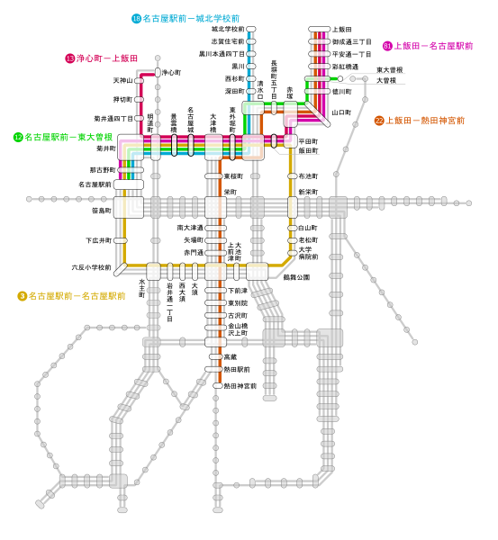
日本語: 1961年4月時点における名古屋市電の運転系統計27系統のうち、明道町-平田町間(行幸線・東片端線)で運転される系統=3・12・13・18・22・81号系統のみを抜き出した系統路線図。 元データの出典:服部重敬『名古屋市電(上)』 ネコ・パブリッシング、2013年、28頁 |
| Date | |
| Source | Own work |
| Author | 継之助 |
| SVG development |
Licensing
[edit]
I, the copyright holder of this work, hereby publish it under the following license:
| This file is made available under the Creative Commons CC0 1.0 Universal Public Domain Dedication. | |
| The person who associated a work with this deed has dedicated the work to the public domain by waiving all of their rights to the work worldwide under copyright law, including all related and neighboring rights, to the extent allowed by law. You can copy, modify, distribute and perform the work, even for commercial purposes, all without asking permission.
|
File history
Click on a date/time to view the file as it appeared at that time.
| Date/Time | Thumbnail | Dimensions | User | Comment | |
|---|---|---|---|---|---|
| current | 15:00, 10 June 2019 | | 1,200 × 1,300 (208 KB) | 継之助 (talk | contribs) | {{Information |description ={{ja|1=1961年4月時点における名古屋市電の運転系統計27系統のうち、明道町-平田町間(行幸線・東片端線)で運転される系統=3・12・13・18・22・81号系統のみを抜き出した系統路線図。<br />元データの出典:服部重敬『名古屋市電(上)』 ネコ・パブリッシング、2013年、28頁}} |date =2019-06-10 |source ={{own}} |author =User:継之助 }} Category:Railway maps of Nagoya City Tram |
You cannot overwrite this file.
File usage on Commons
The following 4 pages use this file:
File usage on other wikis
The following other wikis use this file:
- Usage on ja.wikipedia.org