File:Nagorno-Karabakh War-sr.svg
Jump to navigation
Jump to search

Size of this PNG preview of this SVG file: 443 × 300 pixels. Other resolutions: 320 × 217 pixels | 640 × 433 pixels | 1,024 × 693 pixels | 1,280 × 867 pixels | 2,560 × 1,734 pixels.
Original file (SVG file, nominally 443 × 300 pixels, file size: 178 KB)
Captions
Captions
Add a one-line explanation of what this file represents
Summary
[edit]
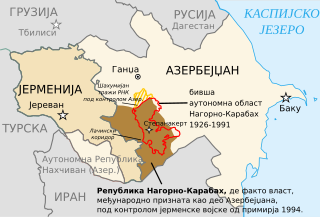
| Description | Carte de l'Azerbaïdjan avec le Haut-Karabakh et la zone contrôlée par l'armée arménienne. |
| Date | (UTC) |
| Source | |
| Author |
|
| This is a retouched picture, which means that it has been digitally altered from its original version. Modifications: translated to serbian. The original can be viewed here: Az-qa-location-fr.svg:
|
Licensing
[edit]
I, the copyright holder of this work, hereby publish it under the following licenses:
| This file is licensed under the Creative Commons Attribution-Share Alike 3.0 Unported license. | ||
| ||
| This licensing tag was added to this file as part of the GFDL licensing update. |

|
Permission is granted to copy, distribute and/or modify this document under the terms of the GNU Free Documentation License, Version 1.2 or any later version published by the Free Software Foundation; with no Invariant Sections, no Front-Cover Texts, and no Back-Cover Texts. A copy of the license is included in the section entitled GNU Free Documentation License. |
You may select the license of your choice.
Original upload log
[edit]
This image is a derivative work of the following images:
- File:Az-qa-location-fr.svg licensed with Cc-by-sa-3.0-migrated, GFDL
- 2008-04-12T13:24:55Z Bourrichon 443x300 (181640 Bytes) orth
- 2008-04-12T12:34:48Z Bourrichon 443x300 (181640 Bytes) déplacement passages
- 2008-04-12T12:28:30Z Bourrichon 443x300 (181670 Bytes) + Goranboy
- 2008-04-12T09:11:07Z Bourrichon 443x300 (176391 Bytes) Ajout de la zone de Goranboy
- 2008-04-11T19:57:36Z Bourrichon 443x300 (162772 Bytes) {{Information |Description= |Source=self-made/[[:Image:Az-qa-location-es.svg]] (GFDL) + information de [[:Image:Nagorno-Karabakh Occupation Map.jpg]]. |Date=11 avril 2008 |Author= [[User:Bourrichon|Bourrichon]] |Permission=GF
Uploaded with derivativeFX
File history
Click on a date/time to view the file as it appeared at that time.
| Date/Time | Thumbnail | Dimensions | User | Comment | |
|---|---|---|---|---|---|
| current | 03:35, 18 October 2011 | | 443 × 300 (178 KB) | BokicaK (talk | contribs) | == {{int:filedesc}} == {{Information |Description=Carte de l'Azerbaïdjan avec le Haut-Karabakh et la zone contrôlée par l'armée arménienne. |Source=*File:Az-qa-location-fr.svg |Date=2011-10-18 03:32 (U |
You cannot overwrite this file.
File usage on Commons
There are no pages that use this file.
File usage on other wikis
The following other wikis use this file:
- Usage on sh.wikipedia.org
- Usage on sr.wikipedia.org