File:Nabaratna Temple.jpg
Jump to navigation
Jump to search

Size of this preview: 800 × 450 pixels. Other resolutions: 320 × 180 pixels | 640 × 360 pixels | 1,024 × 576 pixels | 1,280 × 720 pixels | 2,560 × 1,440 pixels | 4,608 × 2,592 pixels.
Original file (4,608 × 2,592 pixels, file size: 4.18 MB, MIME type: image/jpeg)
Captions
Captions
Add a one-line explanation of what this file represents
Summary
[edit]
| Description |
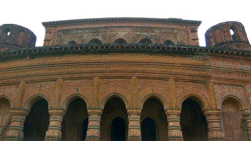
English: Built in nine-spried plan, the temple is a 15.4m square building. Its central shrine measures 2.34m square. It stands on a high platform. Rising on three diminishing stages, it goes by the local name 'Dolmancha'. Most of the 'Ratnas' (spires) have disappeared. The lowest storey of the temple has a central 'GARBHAGRIHA' surrounded by two verandahs. The outer verandah has seven archways on its each side. The central shrine has two arch openings, one in the east and other in the south. The second storey of the temple has been built without outer verandah and the third storey over the central shrine of the temple. The cornice of the temple is gently curved. Brick and lime mortar have been used for the construction of the temple. It is the largest Nabaratna Temple of Bangladesh. In its original state of preservation, the temple was profusely decorated with terracotta ornamentation but now survive a little. The marks of the panels of terracotta plaques are still found on the facade. The temple contains no inscription. But from some textual reference it is known that it was built in between 1704 and 1728 A.D. by one Ramanath Bahaduri who was a revenue collector during the rule of Nawab Murshid Kuli Khan.
বাংলা: একটি উঁচু বেদীর উপর নবরত্ন পরিকল্পনায় নির্মিত মন্দিরের প্রতিটি বাহু ১৫.৪ মিটার দীর্ঘ এবং বর্তমানে ১৩.২৫ মিটার উঁচু। ক্রমহ্রাসমান তিনতলা বিশিষ্ট এ মন্দিরটি স্থানীয়ভাবে 'দোলমঞ্চ' নামে পরিচিত। মন্দিরের উপরের রত্ন বা চূড়াগুলো অধিকাংশ নষ্ট হয়ে গেছে। নীচতলায় দুইটি বারান্দা বেষ্টিত একটি গর্ভগৃহ আছে। এর বারান্দার বাইরের দিকে ৭টি এবং ভেতরের দিকে ৫টি খিলান প্রবেশ পথ আছে। গর্ভগৃহের পূর্ব ও দক্ষিণ দিকে ২টি প্রবেশ পথ রয়েছে। মন্দিরের দ্বিতীয় তলায় বারান্দা নেই। মন্দিরটি ইট, চুন, সুরকির মশল্লা দিয়ে নির্মিত। এটি বাংলাদেশের সবচেয়ে বড় নবরত্ন মন্দির। মূল অবস্থায় মন্দিরটি পোড়ামাটির চিত্রফল দ্বারা সজ্জিত ছিল। এখনও মন্দির গাত্রে সামান্য কিছু চিত্রফলকের চিহ্ন পরিলক্ষিত হয়। মন্দিরটি ছাদপ্রান্ত আংশিক বাঁকানো। এ মন্দিরে কোন শিলালিপি পাওয়া যায়নি। তবে কিছু পাঠজাত বিবরণ থেকে জানা যায় যে, নবাব মুর্শিদকুলি খানের শাসনামলে রামনাথ ভাদুড়ী নামে জনৈক তহসিলদার খ্রি. ১৭০৪-১৭২৮ সালের মধ্যবর্তী সময়ে এটি নির্মাণ করেছিলেন।
|
||
| Date | Taken on 3 September 2016, 16:41:43 | ||
| Source | Own work | ||
| Author | Rehan Uddin Mahmud |
| Camera location | | View this and other nearby images on: OpenStreetMap |
|---|
Licensing
[edit]
I, the copyright holder of this work, hereby publish it under the following license:
This file is licensed under the Creative Commons Attribution-Share Alike 4.0 International license.
- You are free:
- to share – to copy, distribute and transmit the work
- to remix – to adapt the work
- Under the following conditions:
- attribution – You must give appropriate credit, provide a link to the license, and indicate if changes were made. You may do so in any reasonable manner, but not in any way that suggests the licensor endorses you or your use.
- share alike – If you remix, transform, or build upon the material, you must distribute your contributions under the same or compatible license as the original.

|
This image was uploaded as part of Wiki Loves Monuments 2016.
|
 |
File history
Click on a date/time to view the file as it appeared at that time.
| Date/Time | Thumbnail | Dimensions | User | Comment | |
|---|---|---|---|---|---|
| current | 15:31, 4 September 2016 | | 4,608 × 2,592 (4.18 MB) | Rehan.noyon23 (talk | contribs) | User created page with UploadWizard |
You cannot overwrite this file.
File usage on Commons
There are no pages that use this file.
File usage on other wikis
The following other wikis use this file:
- Usage on bn.wikipedia.org