File:NY 25-25A near Paul Givens Park Entrance, Smithtown.jpg
Jump to navigation
Jump to search

Size of this preview: 800 × 600 pixels. Other resolutions: 320 × 240 pixels | 640 × 480 pixels | 1,024 × 768 pixels | 1,280 × 960 pixels | 2,560 × 1,920 pixels | 3,648 × 2,736 pixels.
Original file (3,648 × 2,736 pixels, file size: 2.08 MB, MIME type: image/jpeg)
Captions
Captions
Add a one-line explanation of what this file represents
Summary
[edit]
| Description |
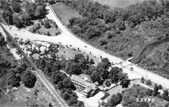
English: Eastbound New York State Routes 25 and 25A on the east bank of the Nissequogue River approaching the sign for Paul T. Given County Park in Smithtown, New York. The park includes an older inadequate version of the bridge over the river currently used as a pedestrian bridge. Additionally, while NY 25-25A run concurrent with one another in Smithtown, the reference routes are strictly for NY 25A. NOTE: Paul T. Givens Park was originally the site of the Frank Friede Riverside Inn. |
| Date | Taken on 16 November 2017, 15:59:38 |
| Source | Own work |
| Author | DanTD |
Licensing
[edit]
I, the copyright holder of this work, hereby publish it under the following license:
This file is licensed under the Creative Commons Attribution-Share Alike 4.0 International license.
- You are free:
- to share – to copy, distribute and transmit the work
- to remix – to adapt the work
- Under the following conditions:
- attribution – You must give appropriate credit, provide a link to the license, and indicate if changes were made. You may do so in any reasonable manner, but not in any way that suggests the licensor endorses you or your use.
- share alike – If you remix, transform, or build upon the material, you must distribute your contributions under the same or compatible license as the original.
File history
Click on a date/time to view the file as it appeared at that time.
| Date/Time | Thumbnail | Dimensions | User | Comment | |
|---|---|---|---|---|---|
| current | 02:29, 30 November 2017 | | 3,648 × 2,736 (2.08 MB) | DanTD (talk | contribs) | User created page with UploadWizard |
You cannot overwrite this file.
File usage on Commons
The following 2 pages use this file:
Metadata
Categories:
- Smithtown, New York
- New York State Route 25 in Suffolk County
- New York State Route 25A
- New York (state) reference markers
- County parks in Suffolk County, New York
- Park signs in New York (state)
- November 2017 in New York (state)
- 2017 in Suffolk County, New York
- Park entrances in the United States
- Two-route concurrencies
- Road signs in the United States photographed in 2017