File:NPS san-antonio-river-walk-map.gif
Jump to navigation
Jump to search

Size of this preview: 201 × 599 pixels. Other resolutions: 80 × 240 pixels | 161 × 480 pixels | 257 × 768 pixels | 343 × 1,024 pixels | 1,760 × 5,247 pixels.
Original file (1,760 × 5,247 pixels, file size: 1.31 MB, MIME type: image/gif, 0.1 s)
Captions
Captions
Add a one-line explanation of what this file represents
Summary
[edit]
| Description |
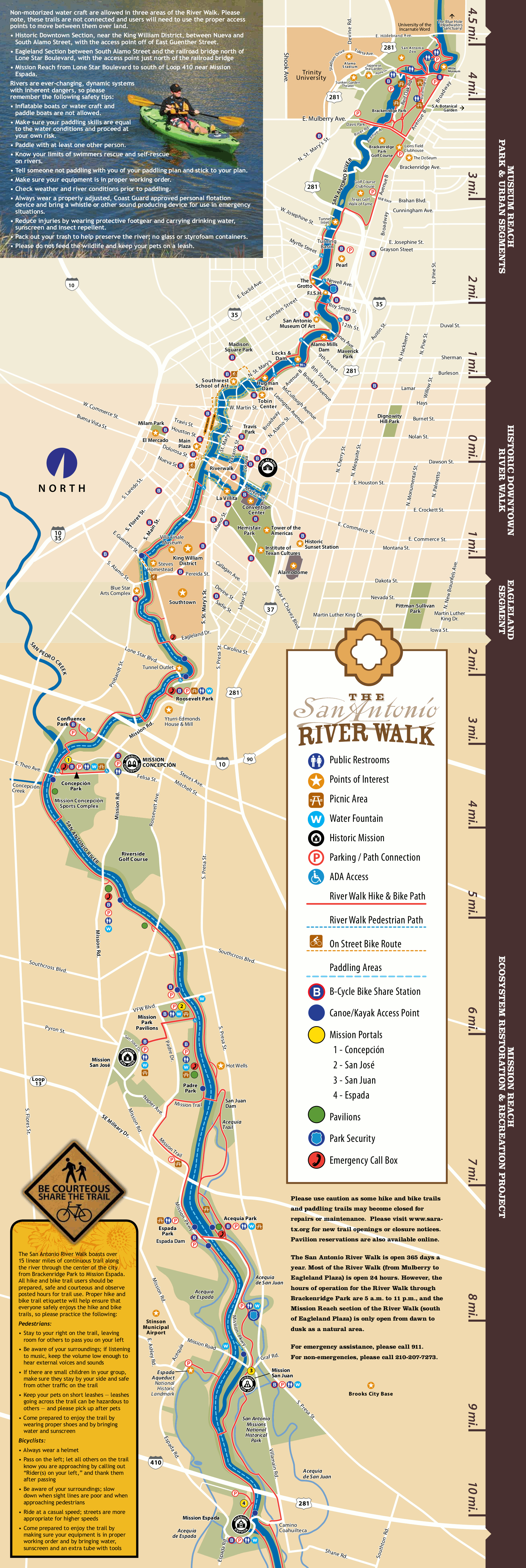
English: San Antonio Riverwalk map, showing the multi-use path that follows the San Antonio River. This map shows the path near the missions as well as beyond park boundaries through San Antonio |
| Date | |
| Source | U.S. National Park Service (http://npmaps.com/wp-content/uploads/san-antonio-river-walk-map.gif) |
| Author | U.S. National Park Service, restoration/cleanup by Matt Holly |
Licensing
[edit]
| This image or media file contains material based on a work of a National Park Service employee, created as part of that person's official duties. As a work of the U.S. federal government, such work is in the public domain in the United States. See the NPS website and NPS copyright policy for more information. |
File history
Click on a date/time to view the file as it appeared at that time.
| Date/Time | Thumbnail | Dimensions | User | Comment | |
|---|---|---|---|---|---|
| current | 09:27, 17 May 2017 | 1,760 × 5,247 (1.31 MB) | RKBot (talk | contribs) | =={{int:filedesc}}== {{Information |description= {{en|1=San Antonio Riverwalk map, showing the multi-use path that follows the San Antonio River. This map shows the path near the missions as well as beyond park boundaries through San Antonio}} |date= 2... |
You cannot overwrite this file.
File usage on Commons
The following page uses this file: