File:NPS ozark-geologic-map-west.jpg
Jump to navigation
Jump to search

Size of this preview: 800 × 473 pixels. Other resolutions: 320 × 189 pixels | 640 × 379 pixels | 1,024 × 606 pixels | 1,280 × 757 pixels | 3,280 × 1,940 pixels.
Original file (3,280 × 1,940 pixels, file size: 2.03 MB, MIME type: image/jpeg)
Captions
Captions
Add a one-line explanation of what this file represents
Summary
[edit]
| Description |
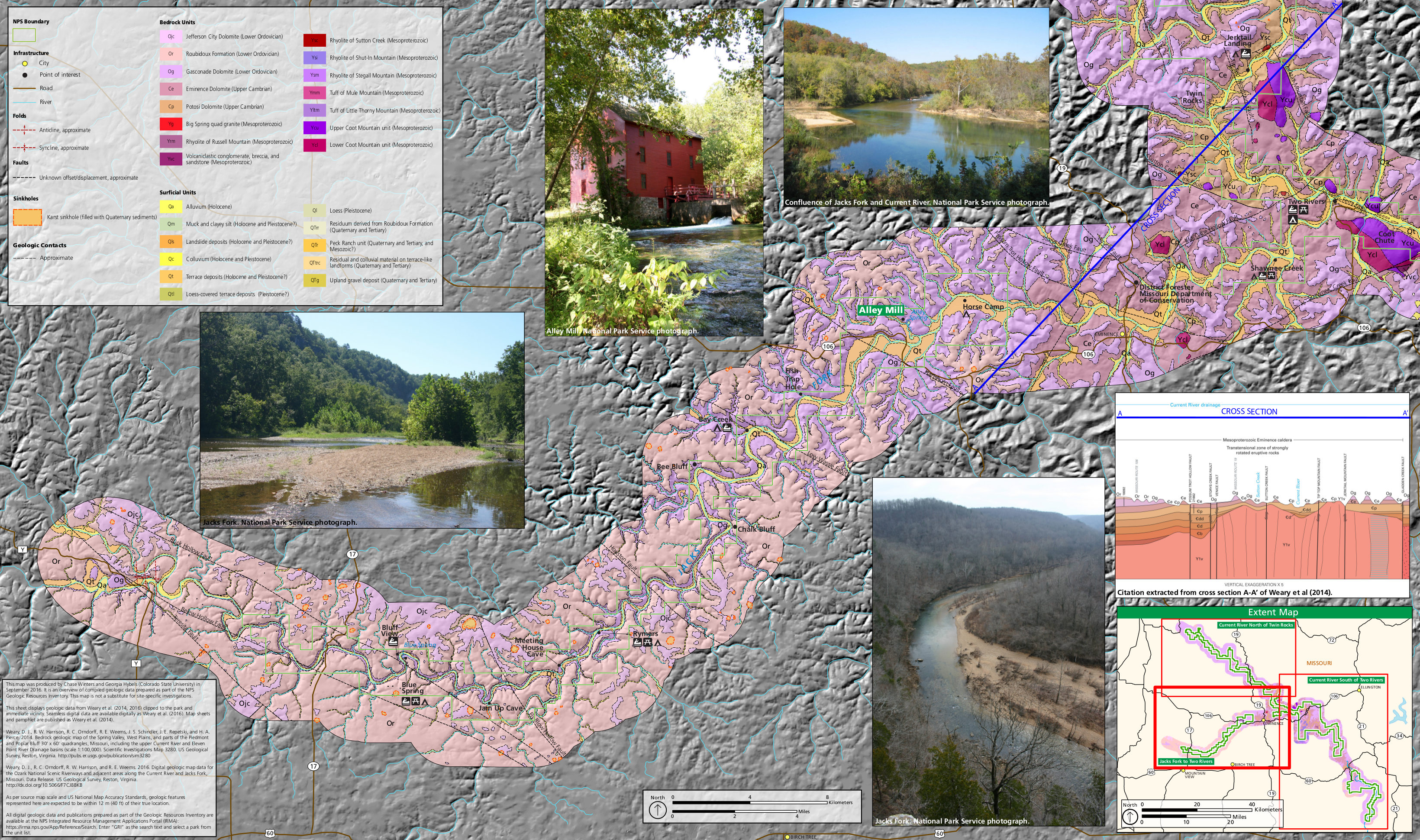
English: This west Ozark geologic map shows the area around the Jacks Fork River, upstream and southeast of Two Rivers. This shows the area just south of the map above. |
| Date | |
| Source | U.S. National Park Service (http://npmaps.com/wp-content/uploads/ozark-geologic-map-west.jpg) |
| Author | U.S. National Park Service, restoration/cleanup by Matt Holly |
Licensing
[edit]
| This image or media file contains material based on a work of a National Park Service employee, created as part of that person's official duties. As a work of the U.S. federal government, such work is in the public domain in the United States. See the NPS website and NPS copyright policy for more information. |
File history
Click on a date/time to view the file as it appeared at that time.
| Date/Time | Thumbnail | Dimensions | User | Comment | |
|---|---|---|---|---|---|
| current | 01:48, 17 May 2017 | | 3,280 × 1,940 (2.03 MB) | RKBot (talk | contribs) | =={{int:filedesc}}== {{Information |description= {{en|1=This west Ozark geologic map shows the area around the Jacks Fork River, upstream and southeast of Two Rivers. This shows the area just south of the map above.}} |date= 2017-01-22 |source= U.S. Na... |
You cannot overwrite this file.
File usage on Commons
The following page uses this file:
Categories:
- Maps of Ozark National Scenic Riverways
- Geological maps of Missouri
- Jefferson City Formation
- Roubidoux Formation
- Gasconade Formation
- Eminence Formation
- Big Spring quad granite
- Rhyolite of Russel Mountain
- Mesoproterozoic volcaniclastic sediments
- Geological cross sections of the United States
- Potosi Dolomite
- Rhyolite of Sutton Creek (Missouri)
- Rhyolite of Shut-in Mountain
- Rhyolite of Stegall Mountain
- Tuff of Mule Mountain
- Tuff of Little Thorny Mountain
- Upper Coot Mountain Unit
- Lower Coot Mountain Unit
- Geological maps of the Ozark Mountains
- Quaternary sinkholes in Missouri
- Jacks Fork River
- Quaternary alluvium in Missouri
- Quaternary silt in Missouri
- Quaternary landslide deposits in Missouri
- Holocene colluvium in Missouri
- Pleistocene colluvium in Missouri
- Quaternary terrace deposits in Missouri
- Quaternary loess in Missouri
- Pleistocene loess in Missouri
- Residuum derived from the Roubidoux Formation
- Peck Ranch Unit
- Quaternary upland gravel deposits in Missouri
- Neogene upland gravel deposits in Missouri
- Mesoproterozoic calderas in the United States
- Mesoproterozoic volcanism of Missouri