File:NPS ozark-geologic-map-east.jpg
Jump to navigation
Jump to search

Size of this preview: 409 × 599 pixels. Other resolutions: 164 × 240 pixels | 328 × 480 pixels | 524 × 768 pixels | 699 × 1,024 pixels | 2,281 × 3,339 pixels.
Original file (2,281 × 3,339 pixels, file size: 2.73 MB, MIME type: image/jpeg)
Captions
Captions
Add a one-line explanation of what this file represents
Summary
[edit]
| Description |
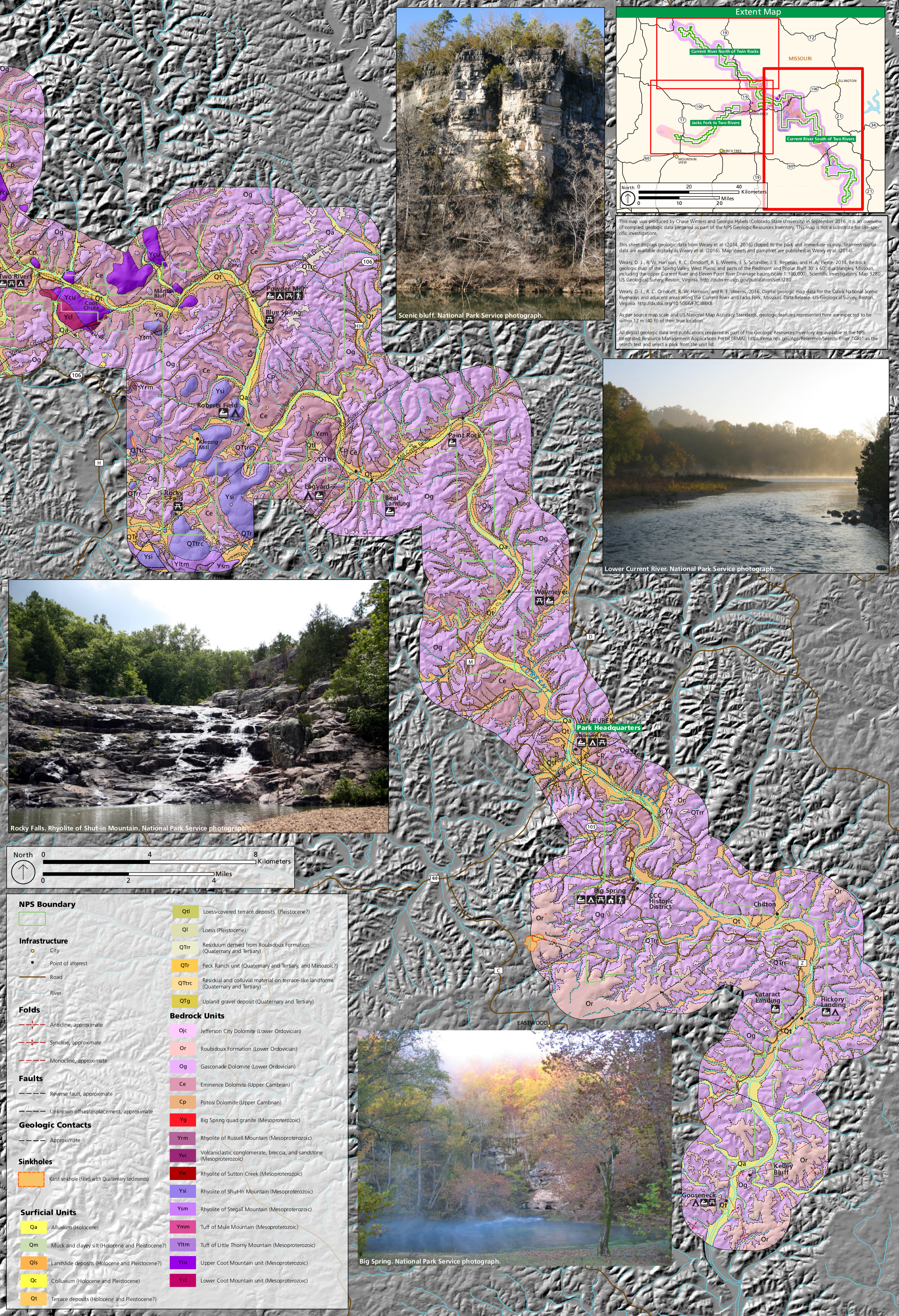
English: The east Ozark geologic map zooms in on the rock layers around the Current River, south of the confluence at Two Rivers. This map shows the area east of the two maps above. |
| Date | |
| Source | U.S. National Park Service (http://npmaps.com/wp-content/uploads/ozark-geologic-map-east.jpg) |
| Author | U.S. National Park Service, restoration/cleanup by Matt Holly |
Licensing
[edit]
| This image or media file contains material based on a work of a National Park Service employee, created as part of that person's official duties. As a work of the U.S. federal government, such work is in the public domain in the United States. See the NPS website and NPS copyright policy for more information. |
File history
Click on a date/time to view the file as it appeared at that time.
| Date/Time | Thumbnail | Dimensions | User | Comment | |
|---|---|---|---|---|---|
| current | 01:48, 17 May 2017 | | 2,281 × 3,339 (2.73 MB) | RKBot (talk | contribs) | =={{int:filedesc}}== {{Information |description= {{en|1=The east Ozark geologic map zooms in on the rock layers around the Current River, south of the confluence at Two Rivers. This map shows the area east of the two maps above.}} |date= 2017-01-22 |so... |
You cannot overwrite this file.
File usage on Commons
The following page uses this file:
Categories:
- Maps of Ozark National Scenic Riverways
- Geological maps of Missouri
- Geological maps of the Ozark Mountains
- Jefferson City Formation
- Roubidoux Formation
- Gasconade Formation
- Eminence Formation
- Big Spring quad granite
- Rhyolite of Russel Mountain
- Mesoproterozoic volcaniclastic sediments in Missouri
- Potosi Dolomite
- Rhyolite of Sutton Creek (Missouri)
- Rhyolite of Shut-in Mountain
- Rhyolite of Stegall Mountain
- Tuff of Mule Mountain
- Tuff of Little Thorny Mountain
- Upper Coot Mountain Unit
- Lower Coot Mountain Unit
- Sinkholes in Missouri
- Holocene alluvium in Missouri
- Quaternary silt in Missouri
- Holocene colluvium in Missouri
- Pleistocene colluvium in Missouri
- Quaternary terrace deposits in Missouri
- Pleistocene loess in Missouri
- Residuum derived from the Roubidoux Formation
- Peck Ranch Unit
- Quaternary sediments in Missouri
- Neogene sediments in Missouri
- Paleogene sediments in Missouri
- Quaternary upland gravel deposits in Missouri
- Neogene upland gravel deposits in Missouri
- Current River (Missouri / Arkansas)