File:NPS katmai-flat-map.jpg
Jump to navigation
Jump to search

Size of this preview: 652 × 600 pixels. Other resolutions: 261 × 240 pixels | 522 × 480 pixels | 835 × 768 pixels | 1,113 × 1,024 pixels | 2,441 × 2,245 pixels.
Original file (2,441 × 2,245 pixels, file size: 2.55 MB, MIME type: image/jpeg)
Captions
Captions
Add a one-line explanation of what this file represents
Summary
[edit]
| Description |
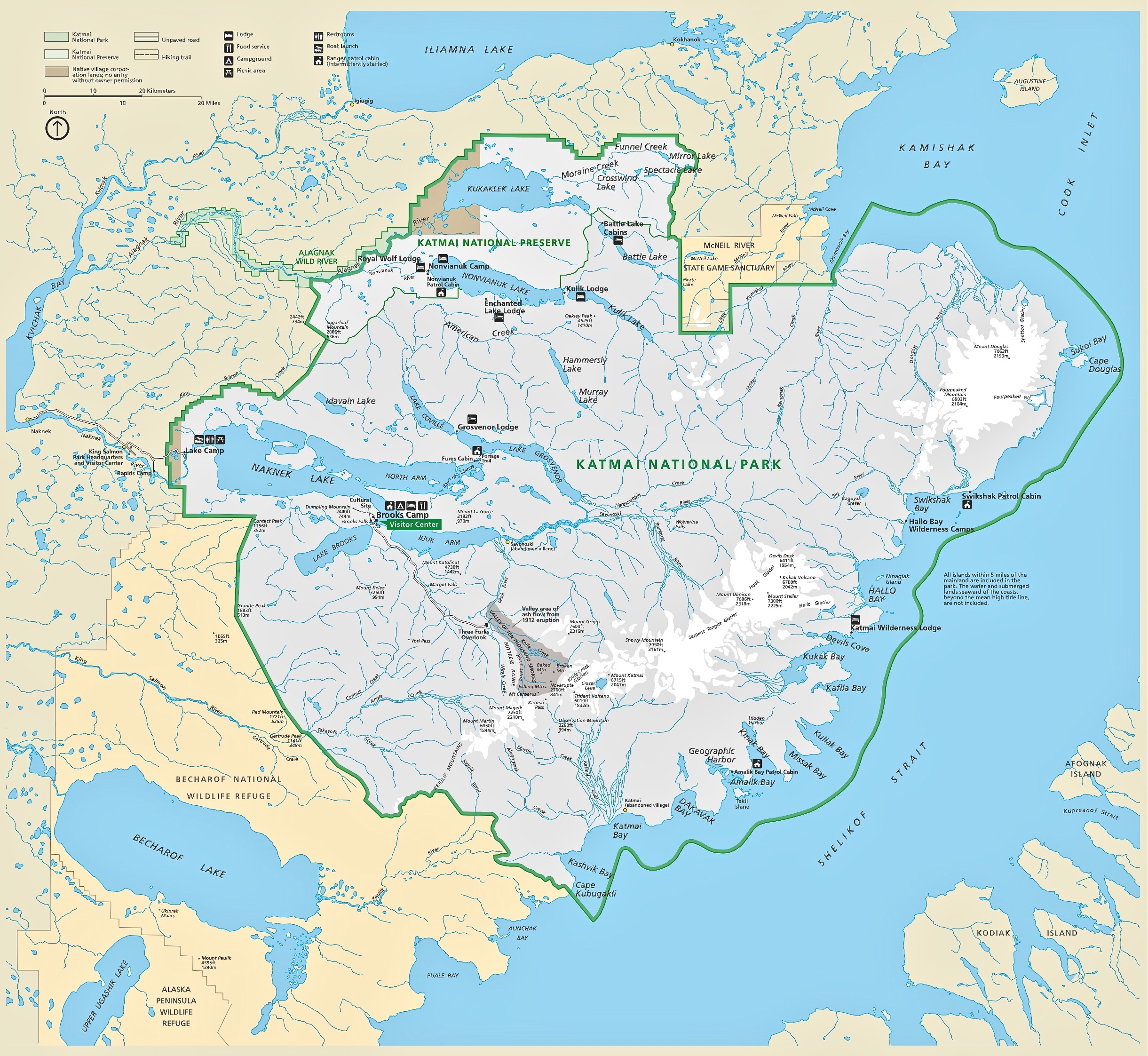
English: Katmai flat map, similar to the full park map listed first on this page but without the topographic relief, so you might find it’s easier to read if you print it at home. |
| Date | |
| Source | U.S. National Park Service (http://npmaps.com/wp-content/uploads/katmai-flat-map.jpg) |
| Author | U.S. National Park Service, restoration/cleanup by Matt Holly |
Licensing
[edit]
| This image or media file contains material based on a work of a National Park Service employee, created as part of that person's official duties. As a work of the U.S. federal government, such work is in the public domain in the United States. See the NPS website and NPS copyright policy for more information. |
File history
Click on a date/time to view the file as it appeared at that time.
| Date/Time | Thumbnail | Dimensions | User | Comment | |
|---|---|---|---|---|---|
| current | 00:30, 17 May 2017 | | 2,441 × 2,245 (2.55 MB) | RKBot (talk | contribs) | =={{int:filedesc}}== {{Information |description= {{en|1=Katmai flat map, similar to the full park map listed first on this page but without the topographic relief, so you might find it’s easier to read if you print it at home.}} |date= 2016-05-15 |so... |
You cannot overwrite this file.
File usage on Commons
The following 2 pages use this file:
Metadata
Categories:
- Maps of Katmai National Park
- Maps of Naknek Lake
- Maps of the Valley of Ten Thousand Smokes
- Maps of Mount Douglas (Alaska)
- Maps of Fourpeaked volcano
- Maps of Mount Katmai
- Maps of Mount Steller (Aleutian Range)
- Maps of Mount Mageik
- Maps of Mount Martin (Alaska)
- Maps of Mount Griggs (Alaska)
- Maps of Trident volcano
- Maps of Novarupta
- Maps of Baked Mountain (Alaska)
- Maps of Mount Cerberus (Katmai)
- Maps of Kukak volcano (Katmai)
- Maps of Mount Denison (Alaska)
- Maps of Snowy Mountain (Katmai)
- Maps of Cook Inlet
- Maps of Shelikof Strait
- Serpent Tongue Glacier
- Maps of Devils Desk (Katmai)
- Hook Glacier (Alaska)