File:NPS katmai-3d-map.jpg
Jump to navigation
Jump to search

Size of this preview: 800 × 522 pixels. Other resolutions: 320 × 209 pixels | 640 × 418 pixels | 1,024 × 668 pixels | 1,280 × 835 pixels | 2,560 × 1,670 pixels | 6,134 × 4,002 pixels.
Original file (6,134 × 4,002 pixels, file size: 3.74 MB, MIME type: image/jpeg)
Captions
Captions
Add a one-line explanation of what this file represents
Summary
[edit]
| Description |
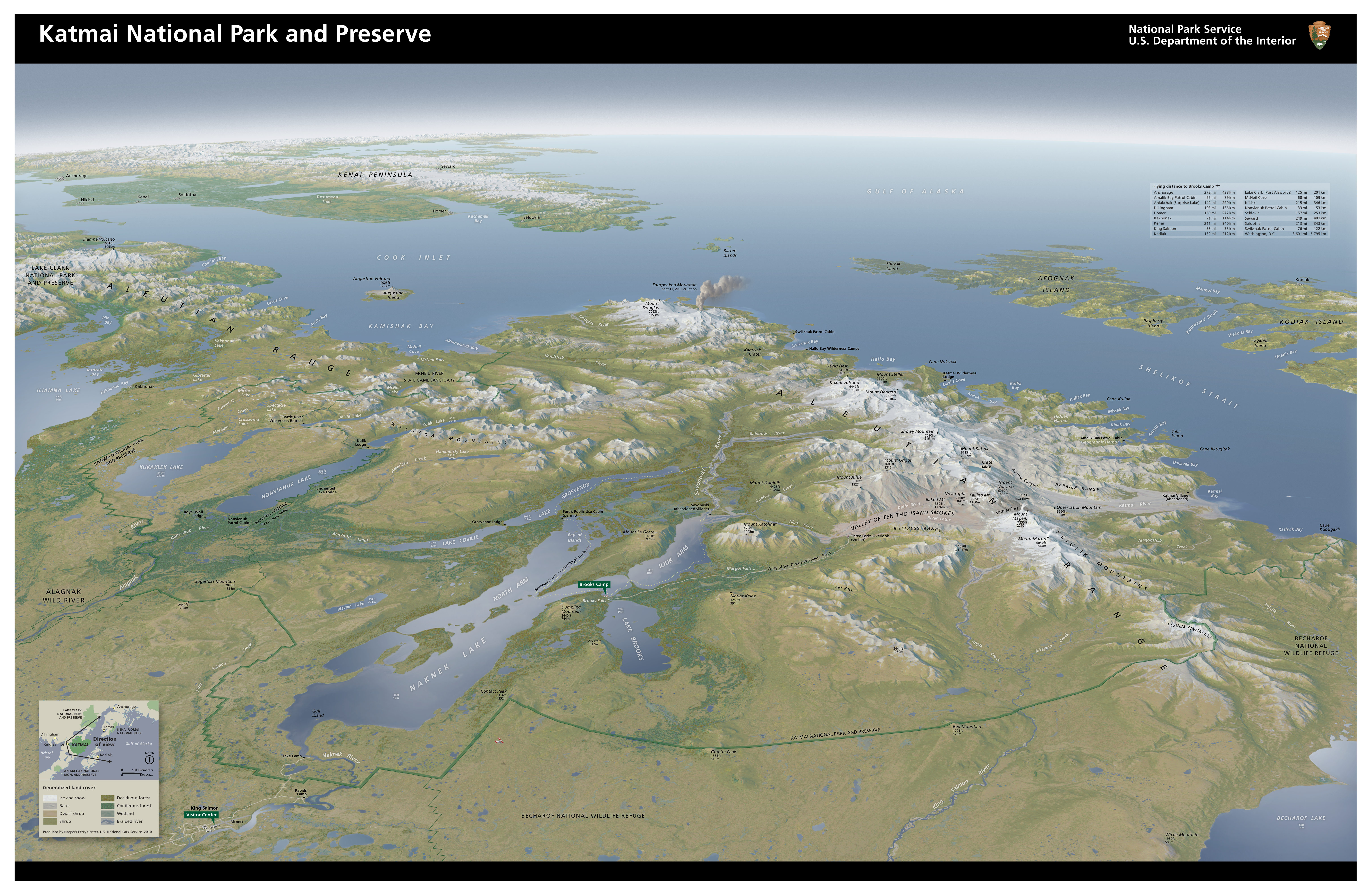
English: Oblique map of Katmai National Park, showing the entire park and volcanoes in full color from a three-dimensional perspective. This map is beautiful – it’s one of my favorites from any park! |
| Date | |
| Source | U.S. National Park Service (http://npmaps.com/wp-content/uploads/katmai-3d-map.jpg) |
| Author | U.S. National Park Service, restoration/cleanup by Matt Holly |
Licensing
[edit]
| This image or media file contains material based on a work of a National Park Service employee, created as part of that person's official duties. As a work of the U.S. federal government, such work is in the public domain in the United States. See the NPS website and NPS copyright policy for more information. |
File history
Click on a date/time to view the file as it appeared at that time.
| Date/Time | Thumbnail | Dimensions | User | Comment | |
|---|---|---|---|---|---|
| current | 00:29, 17 May 2017 | | 6,134 × 4,002 (3.74 MB) | RKBot (talk | contribs) | =={{int:filedesc}}== {{Information |description= {{en|1=Oblique map of Katmai National Park, showing the entire park and volcanoes in full color from a three-dimensional perspective. This map is beautiful – it’s one of my favorites from any park!}}... |
You cannot overwrite this file.
File usage on Commons
The following 2 pages use this file:
Categories:
- Maps of Katmai National Park
- Maps of Mount Douglas (Alaska)
- Maps of the Aleutian Range
- Maps of Mount Katmai
- Mount Mageik
- Maps of Mount Martin (Alaska)
- Maps of Fourpeaked volcano
- Maps of Mount Steller (Aleutian Range)
- Maps of the Valley of Ten Thousand Smokes
- Maps of Naknek Lake
- Maps of Mount Griggs (Alaska)
- Maps of Baked Mountain (Alaska)
- Maps of Novarupta
- Maps of Snowy Mountain (Katmai)
- Maps of Mount Denison (Alaska)
- Maps of Devils Desk (Katmai)
- Topography of Katmai National Park