File:NPS hot-springs-geologic-map.jpg
Jump to navigation
Jump to search

Size of this preview: 800 × 446 pixels. Other resolutions: 320 × 178 pixels | 640 × 357 pixels | 1,024 × 571 pixels | 1,280 × 714 pixels | 3,256 × 1,816 pixels.
Original file (3,256 × 1,816 pixels, file size: 1.79 MB, MIME type: image/jpeg)
Captions
Captions
Add a one-line explanation of what this file represents
Summary
[edit]
| Description |
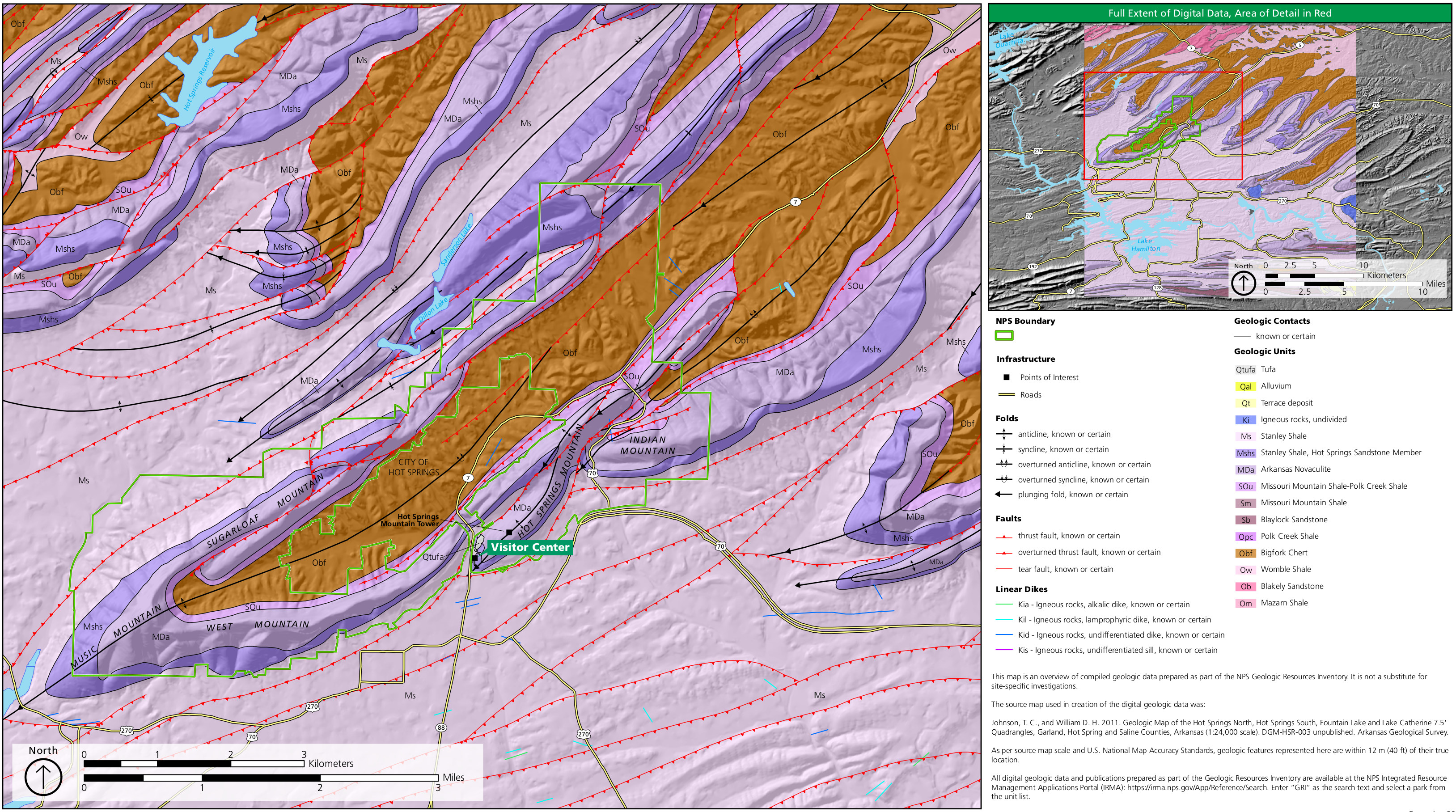
English: The geologic map of Hot Springs National Park zooms in on the national park lands while also showing the bedrock, folds, faults, and dikes in the surrounding region in Arkansas. |
| Date | |
| Source | U.S. National Park Service (http://npmaps.com/wp-content/uploads/hot-springs-geologic-map.jpg) |
| Author | U.S. National Park Service, restoration/cleanup by Matt Holly |
Licensing
[edit]
| This image or media file contains material based on a work of a National Park Service employee, created as part of that person's official duties. As a work of the U.S. federal government, such work is in the public domain in the United States. See the NPS website and NPS copyright policy for more information. |
File history
Click on a date/time to view the file as it appeared at that time.
| Date/Time | Thumbnail | Dimensions | User | Comment | |
|---|---|---|---|---|---|
| current | 23:46, 16 May 2017 | | 3,256 × 1,816 (1.79 MB) | RKBot (talk | contribs) | =={{int:filedesc}}== {{Information |description= {{en|1=The geologic map of Hot Springs National Park zooms in on the national park lands while also showing the bedrock, folds, faults, and dikes in the surrounding region in Arkansas.}} |date= 2017-01-0... |
You cannot overwrite this file.
File usage on Commons
The following page uses this file:
File usage on other wikis
The following other wikis use this file:
- Usage on he.wikipedia.org
Categories:
- Geological maps of Hot Springs National Park
- Geological maps of Arkansas
- Cretaceous magmatic dikes in Arkansas
- Folds in Arkansas
- Anticlines in the United States
- Synclines in the United States
- Faults in Arkansas
- Quaternary tufa in Arkansas
- Quaternary alluvium in Arkansas
- Quaternary terrace deposits in Arkansas
- Cretaceous igneous rocks in Arkansas
- Stanley Shale
- Hot Springs Sandstone
- Arkansas Novaculite
- Missouri Mountain Shale
- Polk Creek Shale
- Blaylock Sandstone
- Bigfork Chert
- Womble Shale
- Blakely Sandstone
- Mazarn Shale