File:NPS grand-teton-flagg-ranch-winter-map.gif
Jump to navigation
Jump to search

Size of this preview: 474 × 600 pixels. Other resolutions: 189 × 240 pixels | 617 × 781 pixels.
Original file (617 × 781 pixels, file size: 47 KB, MIME type: image/gif, 0.1 s)
Captions
Captions
Add a one-line explanation of what this file represents
Summary
[edit]
| Description |
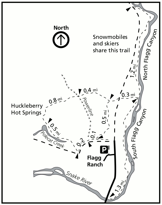
English: This Flagg Ranch winter map shows the northern end of the road, including winter recreation trails to Huckleberry Hot Springs as well as the winter snowmobile road into Yellowstone. |
| Date | |
| Source | U.S. National Park Service (http://npmaps.com/wp-content/uploads/grand-teton-flagg-ranch-winter-map.gif) |
| Author | U.S. National Park Service, restoration/cleanup by Matt Holly |
Licensing
[edit]
| This image or media file contains material based on a work of a National Park Service employee, created as part of that person's official duties. As a work of the U.S. federal government, such work is in the public domain in the United States. See the NPS website and NPS copyright policy for more information. |
File history
Click on a date/time to view the file as it appeared at that time.
| Date/Time | Thumbnail | Dimensions | User | Comment | |
|---|---|---|---|---|---|
| current | 23:23, 16 May 2017 | | 617 × 781 (47 KB) | RKBot (talk | contribs) | =={{int:filedesc}}== {{Information |description= {{en|1=This Flagg Ranch winter map shows the northern end of the road, including winter recreation trails to Huckleberry Hot Springs as well as the winter snowmobile road into Yellowstone.}} |date= 2013-... |
You cannot overwrite this file.
File usage on Commons
The following page uses this file: