File:NPS crater-lake-map.jpg
Jump to navigation
Jump to search

Size of this preview: 515 × 600 pixels. Other resolutions: 206 × 240 pixels | 412 × 480 pixels | 659 × 768 pixels | 879 × 1,024 pixels | 2,467 × 2,873 pixels.
Original file (2,467 × 2,873 pixels, file size: 1.74 MB, MIME type: image/jpeg)
Captions
Captions
Add a one-line explanation of what this file represents
Summary
[edit]
| Description |
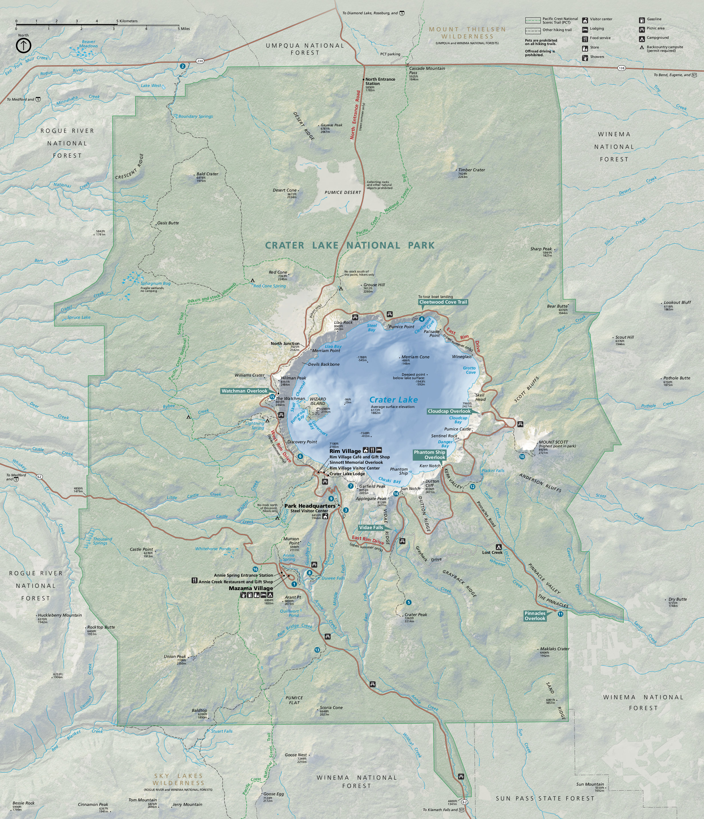
English: Official Crater Lake map from the park brochure, showing roads, trails, campgrounds, and points of interest. |
| Date | |
| Source | U.S. National Park Service (http://npmaps.com/wp-content/uploads/crater-lake-map.jpg) |
| Author | U.S. National Park Service, restoration/cleanup by Matt Holly |
| Other versions |
 |
Licensing
[edit]
| This image or media file contains material based on a work of a National Park Service employee, created as part of that person's official duties. As a work of the U.S. federal government, such work is in the public domain in the United States. See the NPS website and NPS copyright policy for more information. |
File history
Click on a date/time to view the file as it appeared at that time.
| Date/Time | Thumbnail | Dimensions | User | Comment | |
|---|---|---|---|---|---|
| current | 20:09, 16 May 2017 | | 2,467 × 2,873 (1.74 MB) | RKBot (talk | contribs) | =={{int:filedesc}}== {{Information |description= {{en|1=Official Crater Lake map from the park brochure, showing roads, trails, campgrounds, and points of interest.}} |date= 2014-01-13 |source= U.S. National Park Service (http://npmaps.com/wp-content/u... |
You cannot overwrite this file.
File usage on Commons
The following 3 pages use this file:
File usage on other wikis
The following other wikis use this file:
- Usage on en.wikipedia.org
- Usage on www.wikidata.org
Categories:
- Maps of Crater Lake National Park
- Merriam Cone
- Wizard Island
- Grouse Hill (Mt. Mazama)
- Skell Head (Mount Mazama-Crater Lake)
- Maps of Crater Lake
- Pumice Castle
- Bathymetric maps of lakes in the United States
- Bald Crater (Oregon)
- Red Cone (Mount Mazama)
- Desert Cone (Oregon)
- Pumice Desert
- Timber Crater
- Desert Ridge (Oregon)
- Kerr Notch (Crater Lake)
- Mount Scott (Klamath County, Oregon)
- Union Peak
- Crater Peak (Oregon)
- Fumarole Bay (Crater Lake)