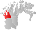
File:NO 2012 Alta.svg
From Wikimedia Commons, the free media repository
Jump to navigation
Jump to search

Size of this PNG preview of this SVG file: 569 × 458 pixels. Other resolutions: 298 × 240 pixels | 596 × 480 pixels | 954 × 768 pixels | 1,272 × 1,024 pixels | 2,544 × 2,048 pixels.
Original file (SVG file, nominally 569 × 458 pixels, file size: 117 KB)
File information
Structured data
Captions
Captions
Add a one-line explanation of what this file represents
| DescriptionNO 2012 Alta.svg |
Norsk bokmål: Kart som viser Maps of Alta municipalitys plassering innen Finnmark, laga av Jon Harald Søby.
English: Map showing the position of Maps of Alta municipality within Finnmark, made by Jon Harald Søby.
Svenska: Karta som visar Maps of Alta municipality kommuns läge i Finnmark fylke, skapad av Jon Harald Søby. |
|||
| Date | ||||
| Source | Own work | |||
| Author | Jon Harald Søby | |||
| Permission (Reusing this file) |
|
|||
| SVG development InfoField |
File history
Click on a date/time to view the file as it appeared at that time.
| Date/Time | Thumbnail | Dimensions | User | Comment | |
|---|---|---|---|---|---|
| current | 19:23, 15 December 2019 |  | 569 × 458 (117 KB) | Jay1279 (talk | contribs) | improved accuracy |
| 20:12, 22 January 2007 |  | 558 × 462 (99 KB) | Jon Harald Søby (talk | contribs) | {{User:Jon Harald Søby/Kartlisens|Alta|Finnmark}} |
You cannot overwrite this file.
File usage on Commons
The following page uses this file:
File usage on other wikis
The following other wikis use this file:
- Usage on ar.wikipedia.org
- Usage on bpy.wikipedia.org
- Usage on ca.wikipedia.org
- Usage on da.wikipedia.org
- Usage on en.wikipedia.org
- Usage on es.wikipedia.org
- Usage on fa.wikipedia.org
- Usage on fr.wikipedia.org
- Usage on hr.wikipedia.org
- Usage on hu.wikipedia.org
- Usage on hy.wikipedia.org
- Usage on id.wikipedia.org
- Usage on is.wikipedia.org
- Usage on it.wikipedia.org
- Usage on ka.wikipedia.org
- Usage on ko.wikipedia.org
- Usage on li.wikipedia.org
- Usage on nds.wikipedia.org
- Usage on nn.wikipedia.org
- Usage on no.wikipedia.org
- Usage on pnb.wikipedia.org
- Usage on pt.wikipedia.org
- Usage on ro.wikipedia.org
- Usage on ru.wikipedia.org
- Usage on se.wikipedia.org
- Usage on sh.wikipedia.org
- Usage on sq.wikipedia.org
- Usage on sv.wikipedia.org
- Usage on th.wikipedia.org
- Usage on tr.wikipedia.org
- Usage on ur.wikipedia.org
- Usage on vi.wikipedia.org
- Usage on www.wikidata.org
- Usage on zh-min-nan.wikipedia.org
Metadata
This file contains additional information such as Exif metadata which may have been added by the digital camera, scanner, or software program used to create or digitize it. If the file has been modified from its original state, some details such as the timestamp may not fully reflect those of the original file. The timestamp is only as accurate as the clock in the camera, and it may be completely wrong.
| Width | 569.2168 |
|---|---|
| Height | 458.02539 |