File:NOAA Satellites and Data Help Predict Heat Waves (NESDIS 2021-08-03).gif
Jump to navigation
Jump to search

Size of this preview: 800 × 450 pixels. Other resolutions: 320 × 180 pixels | 640 × 360 pixels | 960 × 540 pixels.
Original file (960 × 540 pixels, file size: 19.12 MB, MIME type: image/gif, looped, 81 frames, 1 min 5 s)
Captions
Captions
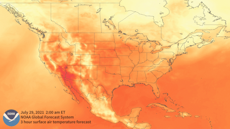
Sweltering temperatures continue to cover large portions of North America, and the excessive heat has not only contributed to a massive drought in the West, but is also fueling wildfires that are creating their own weather.
Summary
[edit].gif&action=edit§ion=1)
| Description |
English: Sweltering temperatures continue to cover large portions of North America, and the excessive heat has not only contributed to a massive drought in the West, but is also fueling wildfires that are creating their own weather. This animated loop from last week shows the predicted surface air temperature from July 29 to Aug. 6. Based on the Global Forecast System (GFS), a NOAA’s National Centers for Environmental Prediction (NCEP) weather forecast model run by the National Weather Service, the map’s dark orange and red colors represent the extreme heat expected across the West and the Northern Plains in late July. The yellow colors indicate cooler temperatures moving into the Great Lakes and Northeast for the beginning of August. The GFS is a global numerical weather prediction system which utilizes both remotely sensed observations from satellites, aircraft, ships, and other observational networks as well as in-situ measurements on the ground. In-situ measurements, unlike remote sensing, require instruments to be located directly in contact with what is being measured, such as buoys in ocean water or an anemometer measuring wind. “Most of the data incorporated into the model comes from both polar and geostationary-orbiting satellites,” said Vijay Tallapragada, Chief of NOAA’s Modeling and Data Assimilation Branch and GFS Project Manager at NCEP. “I don’t have exact numbers, but I’d say about 90 percent comes from satellites and 10% from other sources.” |
| Date | 3 August 2021 (upload date) |
| Source | NOAA Satellites and Data Help Predict Heat Waves |
| Author | NOAA |
Licensing
[edit].gif&action=edit§ion=2)
This image is in the public domain because it contains materials that originally came from the U.S. National Oceanic and Atmospheric Administration, taken or made as part of an employee's official duties.
|
File history
Click on a date/time to view the file as it appeared at that time.
| Date/Time | Thumbnail | Dimensions | User | Comment | |
|---|---|---|---|---|---|
| current | 23:00, 4 June 2024 | | 960 × 540 (19.12 MB) | OptimusPrimeBot (talk | contribs) | #Spacemedia - Upload of https://www.nesdis.noaa.gov/s3/2021-08/20210729-0807_5pm-GFST01_b.gif via Commons:Spacemedia |
You cannot overwrite this file.
File usage on Commons
There are no pages that use this file.
File usage on other wikis
The following other wikis use this file:
- Usage on cs.wikipedia.org
.gif&oldid=881365918)