File:NNSA-NSO-904.jpg
Jump to navigation
Jump to search

Size of this preview: 479 × 600 pixels. Other resolutions: 192 × 240 pixels | 639 × 800 pixels.
Original file (639 × 800 pixels, file size: 123 KB, MIME type: image/jpeg)
Captions
Captions
Add a one-line explanation of what this file represents
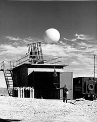
| Description | Indian Springs AFB, Nevada, April 20, 1952 -- The USAF weather station shown above is situated near the Control Point at the Atomic Energy Commission's Nevada Proving Grounds. During periodic continental tests weather personnel send many helium-filled Raob (radar-observer) balloons to the upper atmosphere to check on temperatures, dew points, humidity and wind velocities as a continuing procedure for each atomic detonation. The radar tracking instrument, located on top of the test weather station, charts wind velocities and directions to determine post-detonation paths of radioactive clouds and suspended particles. | |||
| Source |
|
|||
| Author | National Nuclear Security Administration / Nevada Site Office | |||
| Permission (Reusing this file) |
|

File history
Click on a date/time to view the file as it appeared at that time.
| Date/Time | Thumbnail | Dimensions | User | Comment | |
|---|---|---|---|---|---|
| current | 13:55, 2 September 2012 | | 639 × 800 (123 KB) | Bomazi (talk | contribs) | {{Information |Description=Indian Springs AFB, Nevada, April 20, 1952 -- The USAF weather station shown above is situated near the Control Point at the Atomic Energy Commission's Nevada Proving Grounds. During periodic continental tests weat... |
You cannot overwrite this file.
File usage on Commons
There are no pages that use this file.