File:NM23-764-236.JPG
Jump to navigation
Jump to search
Size of this preview: 600 × 600 pixels. Other resolutions: 240 × 240 pixels | 480 × 480 pixels | 768 × 768 pixels | 1,024 × 1,024 pixels | 2,048 × 2,048 pixels | 4,016 × 4,016 pixels.
Original file (4,016 × 4,016 pixels, file size: 19.16 MB, MIME type: image/jpeg)
Captions
Captions
Add a one-line explanation of what this file represents
Summary
[edit]
| Description |
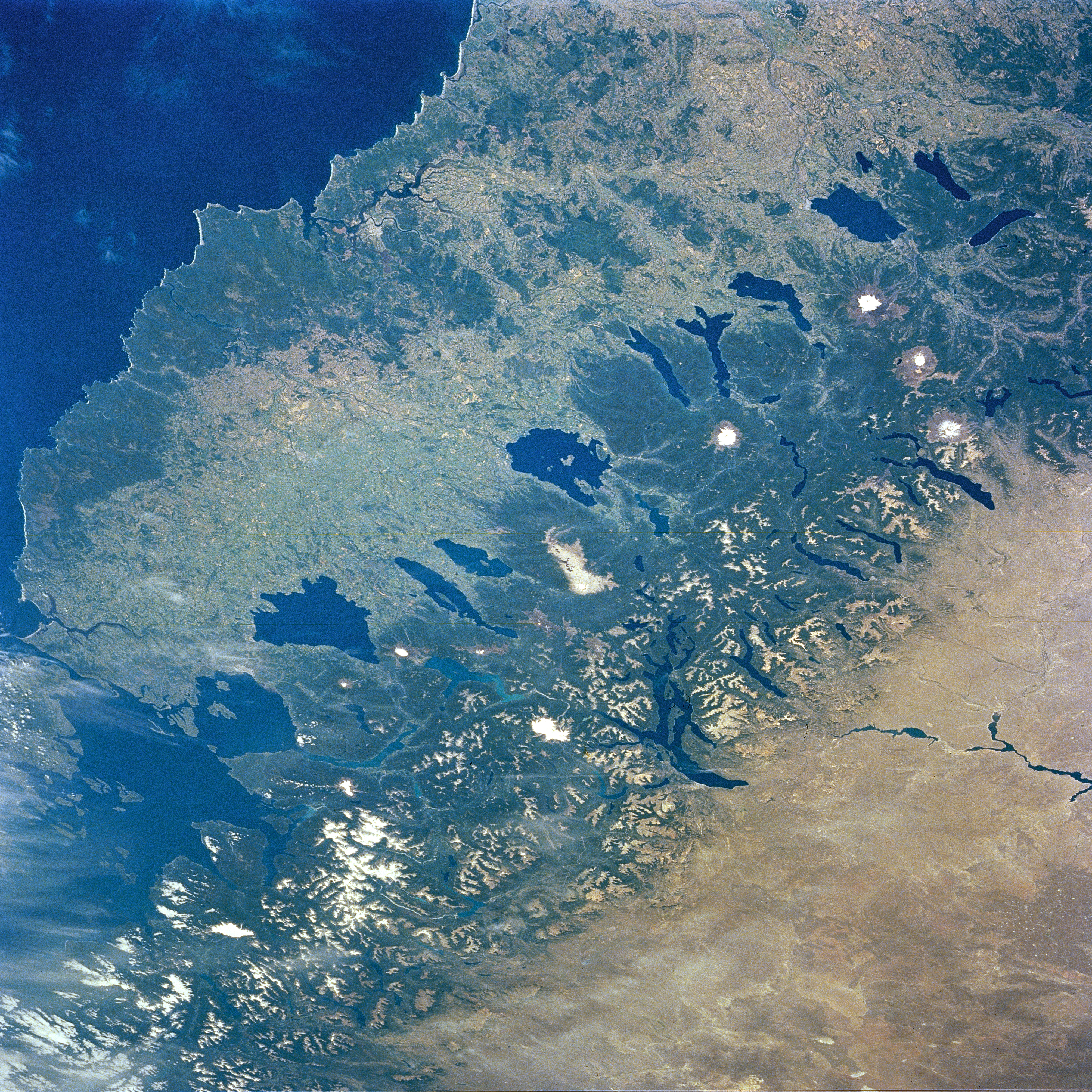
English: NASA says: NM23-764-236 Southern Andes Mountains, Central Valley, Chile Winter/Spring 1997
Many volcanic peaks, snowcapped ridges and glacial lakes of the southern Andes Mountains are visible in this southeast-looking view. Between the mountains and the Pacific Ocean (lower right), the long, narrow, fertile Central Valley of Chile appears distinctly greener—on the wet side of the mountains—compared with the dry plains of Patagonia (top left). The Central Valley stretches southward to where it drops below sea level into the Gulf of Ancud (upper right). The glacial lakes of the forested slopes of the Andes begin with Lakes Colico, Caburgua, and Villarrica (bottom left portion of the image). Between Lakes Villarrica and Calafquén is the snow-covered stratovolcano Villarrica, which is active at this writing. The large lake with the small island near its center is Lake Ranco. Just to the south-southeast of Lake Ranco and at the center of the image is the Cordillera Nevada. The narrow complex lake on the Patagonian side of the Cordillera Nevada is Lake Nahuel Huapi. The large lake at the southern end of the Central Valley is Llanquihue. Chile’s major southern port of Puerto Montt is the small white patch at the north end of the Bay of Seno de Reloncavi (just south of Lake Llanquihue). Covering the upper left and top center of the image is the Patagonian Plateau. |
| Date | |
| Source | https://eol.jsc.nasa.gov/SearchPhotos/photo.pl?mission=NM23&roll=764&frame=236 |
| Author | NASA |
| Other versions | File:Chile.Los Lagos y Los Ríos.svg (reduced to 1000x1000, rotated and labeled) |
Licensing
[edit]
| This file is in the public domain in the United States because it was solely created by NASA. NASA copyright policy states that "NASA material is not protected by copyright unless noted". (See Template:PD-USGov, NASA copyright policy page or JPL Image Use Policy.) | ||
 |
Warnings:
|
| Annotations | This image is annotated: View the annotations at Commons |
File history
Click on a date/time to view the file as it appeared at that time.
| Date/Time | Thumbnail | Dimensions | User | Comment | |
|---|---|---|---|---|---|
| current | 20:01, 30 January 2018 | | 4,016 × 4,016 (19.16 MB) | SteinsplitterBot (talk | contribs) | Bot: Image rotated by 180° |
| 08:39, 15 May 2013 |  | 4,024 × 4,024 (16.34 MB) | Keysanger (talk | contribs) | User created page with UploadWizard |
You cannot overwrite this file.
File usage on Commons
The following page uses this file:
File usage on other wikis
The following other wikis use this file:
- Usage on ru.wikipedia.org