File:NJT railmap.svg
Jump to navigation
Jump to search

Size of this PNG preview of this SVG file: 329 × 600 pixels. Other resolutions: 131 × 240 pixels | 263 × 480 pixels | 421 × 768 pixels | 561 × 1,024 pixels | 1,123 × 2,048 pixels | 2,720 × 4,960 pixels.
Original file (SVG file, nominally 2,720 × 4,960 pixels, file size: 292 KB)
Captions
Captions
Add a one-line explanation of what this file represents
Summary
[edit]| Description |
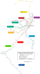
English: A map of NJ Transit's commuter rail line (plus the River Line) showing stations and routes |
| Date | 5 August 2006 (first version) |
| Source | Created by tracing over a public domain NJDOT railroads map in Inkscape |
| Author | User:lensovet |
| Other versions | Derivative works of this file: NJT railmap infobox.svg |
Licensing
[edit]| I, lensovet, the author of this work, hereby publish it under the following licenses: | ||||
To provide attribution, credit the author as lensovet. You may select the license of your choice. |

File history
Click on a date/time to view the file as it appeared at that time.
| Date/Time | Thumbnail | Dimensions | User | Comment | |
|---|---|---|---|---|---|
| current | 05:29, 23 May 2012 | | 2,720 × 4,960 (292 KB) | Pi.1415926535 (talk | contribs) | Metro Park --> Metropark |
| 20:00, 16 July 2011 |  | 2,720 × 4,960 (292 KB) | Pi.1415926535 (talk | contribs) | Fixed New bridge Landing name | |
| 18:36, 16 July 2011 |  | 2,720 × 4,960 (292 KB) | Pi.1415926535 (talk | contribs) | Corrected geographic route of Meadowlands Rail Line; changed Princeton Junction to official name | |
| 00:49, 15 January 2010 |  | 2,720 × 4,960 (292 KB) | Mitchazenia (talk | contribs) | Some cosmetics had some problems | |
| 00:40, 15 January 2010 |  | 2,720 × 4,960 (293 KB) | Mitchazenia (talk | contribs) | update for Great Notch, some cosmetics | |
| 22:02, 26 September 2009 |  | 2,720 × 4,960 (295 KB) | Mitchazenia (talk | contribs) | Meadowlands | |
| 21:48, 20 September 2009 |  | 2,720 × 4,960 (295 KB) | Mitchazenia (talk | contribs) | fix | |
| 13:35, 19 September 2009 |  | 2,720 × 4,960 (295 KB) | Mitchazenia (talk | contribs) | Upload with 1. Removal of Finderne station 2. Adding of Wayne-Route 23 3. Adding of Meadowlands Rail Station 4. Adding of Mount Arlington Rail Station 5. Signed name of Princeton Junction | |
| 02:47, 19 September 2009 |  | 2,720 × 4,960 (293 KB) | Oknazevad (talk | contribs) | Reverted to version as of 20:12, 5 August 2006, new map of limited interest, prone to crystal balling | |
| 01:38, 19 September 2009 |  | 2,720 × 4,960 (3.4 MB) | Mitchazenia (talk | contribs) | :| |
You cannot overwrite this file.
File usage on Commons
The following 2 pages use this file:
File usage on other wikis
The following other wikis use this file:
- Usage on ja.wikipedia.org