File:NEXRAD MESO-SAILS scanning strategy.png
Jump to navigation
Jump to search
Size of this preview: 800 × 600 pixels. Other resolutions: 320 × 240 pixels | 640 × 480 pixels | 960 × 720 pixels.
Original file (960 × 720 pixels, file size: 684 KB, MIME type: image/png)
Captions
Captions
Add a one-line explanation of what this file represents
Summary
[edit]
| Description |
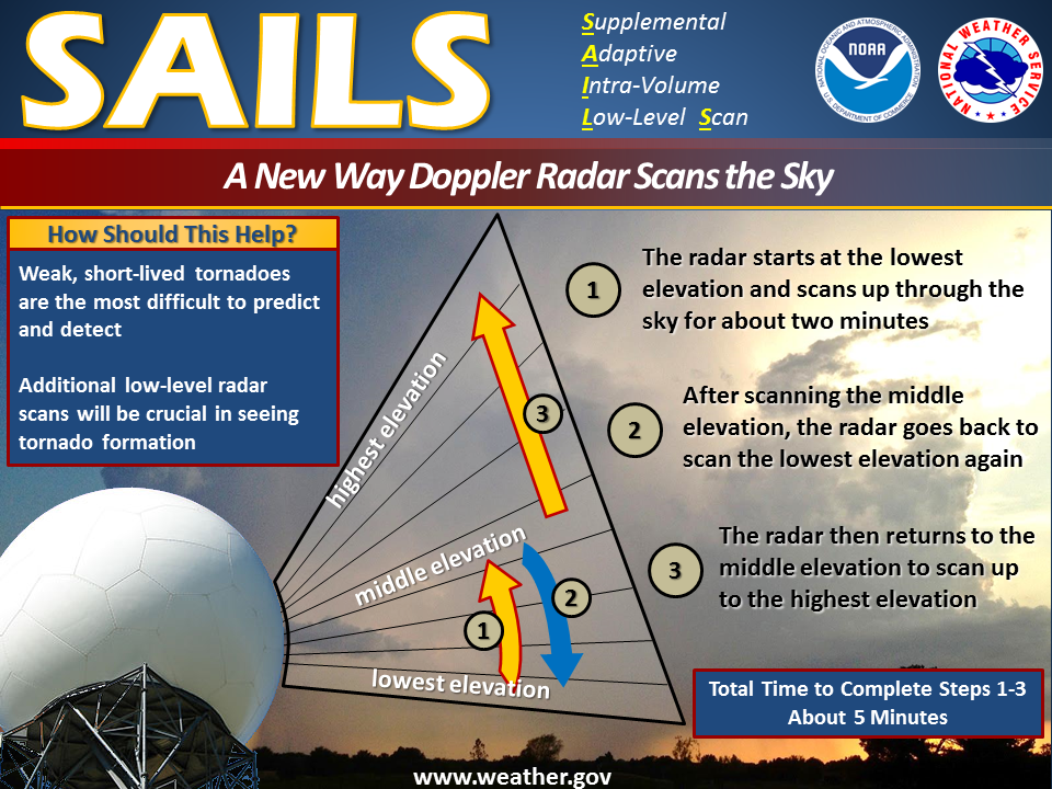
English: An improvement to the WSR-88D radar scanning strategy is called MESO-SAILS, Multiple Elevation Scan Option-SAILS. It enables the radar to provide up to four low-level views of the storm within a five minute period. This is done by coming back down regularly to the lowest scanned elevation during the course of a full vertical scans of many angles.
Because of this, the forecaster can see the lowest and most important portion of the storm as quickly as every 75 seconds. That means better and faster detection of hazardous weather, ultimately leading to more advanced warnings. |
| Date | |
| Source | http://www.nws.noaa.gov/com/weatherreadynation/news/151509_meso_sails.html |
| Author | US national Weather Service of NOAA |
Licensing
[edit]
This image is in the public domain because it contains materials that originally came from the U.S. National Oceanic and Atmospheric Administration, taken or made as part of an employee's official duties.
|
File history
Click on a date/time to view the file as it appeared at that time.
| Date/Time | Thumbnail | Dimensions | User | Comment | |
|---|---|---|---|---|---|
| current | 23:05, 7 February 2017 | | 960 × 720 (684 KB) | Pierre cb (talk | contribs) | User created page with UploadWizard |
You cannot overwrite this file.
File usage on Commons
The following page uses this file:
File usage on other wikis
The following other wikis use this file:
- Usage on en.wikipedia.org