File:NEAT Gotthardachse South.jpg
Jump to navigation
Jump to search
Size of this preview: 539 × 600 pixels. Other resolutions: 216 × 240 pixels | 431 × 480 pixels | 852 × 948 pixels.
Original file (852 × 948 pixels, file size: 356 KB, MIME type: image/jpeg)
Captions
Captions
Add a one-line explanation of what this file represents
source: http://de.wikipedia.org/wiki/Bild:NEAT_Gotthardachse_S%C3%BCd.jpg
Summary
[edit]
| Description |
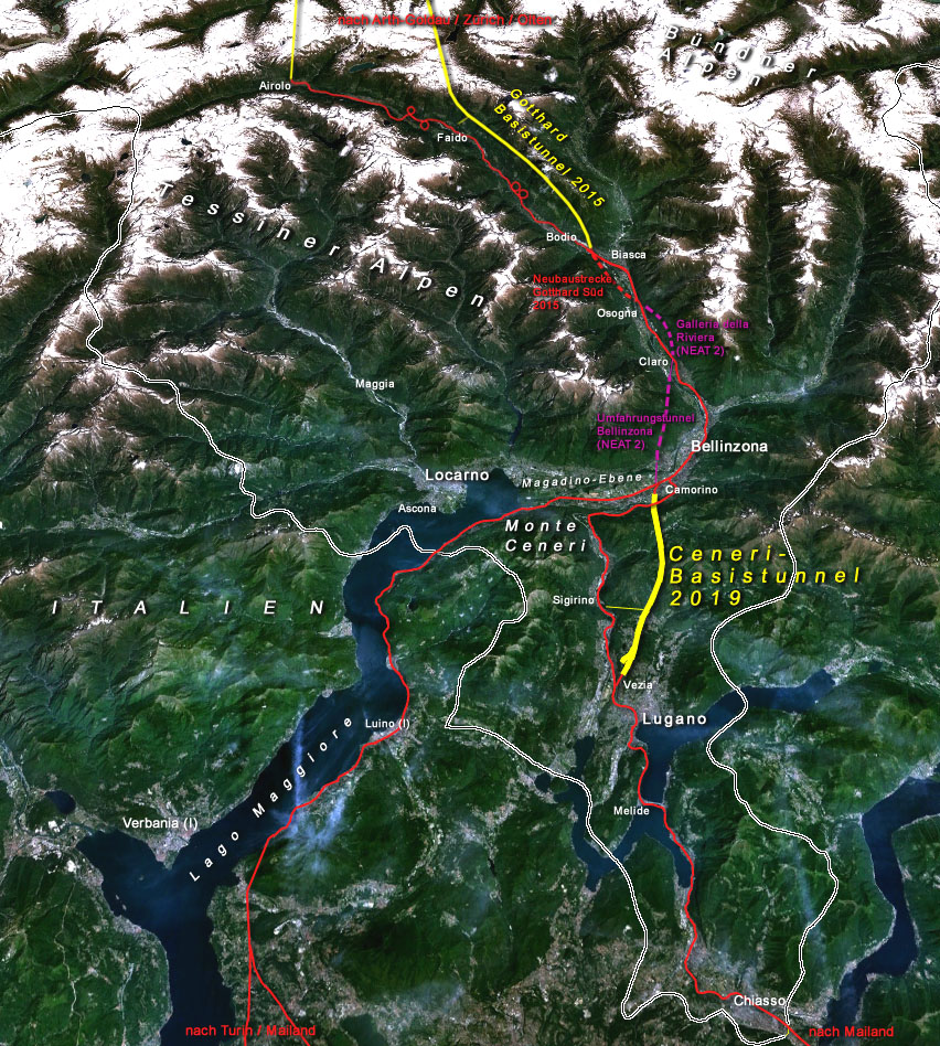
Deutsch: Situation der Gotthardachse Süd der Neuen Eisenbahn-Alpentransversale NEAT in der Schweiz (Tessin) mit dem Ceneri-Basistunnel (pink: diese Tunnels sowie die Magadino-Querung und der Knoten Camorino sind Projektstudien im Rahmen der sogenannten NEAT 2) |
| Date | |
| Source |
Deutsch: Geländerelief: NASA WorldWind 1.3 / Zeichnung: Cooper |
| Author | uploaded to de: by de:Benutzer:Cooper |
| Permission (Reusing this file) |
Deutsch: NASA-Daten sind public domain, meine darübergelegte Skizzierung erreicht nicht die nötige Schöpfungshöhe. |
| Other versions | Image:NEAT_Lötschbergachse.png, Image:NEAT_Gotthardachse.png |
Licensing
[edit]
| This file is in the public domain in the United States because it was solely created by NASA. NASA copyright policy states that "NASA material is not protected by copyright unless noted". (See Template:PD-USGov, NASA copyright policy page or JPL Image Use Policy.) | ||
 |
Warnings:
|
| Annotations | This image is annotated: View the annotations at Commons |
File history
Click on a date/time to view the file as it appeared at that time.
| Date/Time | Thumbnail | Dimensions | User | Comment | |
|---|---|---|---|---|---|
| current | 16:53, 7 April 2008 | | 852 × 948 (356 KB) | Ori~ (talk | contribs) | source: http://de.wikipedia.org/wiki/Bild:NEAT_Gotthardachse_S%C3%BCd.jpg == Beschreibung, Quelle == Information Beschreibung=Situation der Gotthardachse Süd der ''Neuen Eisenbahn-Alpentransversale'' NEAT in der Schweiz (pink: diese Tunnels sowie die |
You cannot overwrite this file.
File usage on Commons
The following 2 pages use this file:
File usage on other wikis
The following other wikis use this file:
- Usage on da.wikipedia.org
- Usage on de.wikipedia.org
- Usage on en.wikipedia.org
- Usage on es.wikipedia.org
- Usage on fr.wikipedia.org
- Usage on hu.wikipedia.org
- Usage on it.wikipedia.org
- Usage on ja.wikipedia.org
- Usage on lmo.wikipedia.org
- Usage on pt.wikipedia.org
- Usage on sl.wikipedia.org
- Usage on uk.wikipedia.org
- Usage on zh.wikipedia.org