File:NCR Plus.svg
Jump to navigation
Jump to search

Size of this PNG preview of this SVG file: 800 × 559 pixels. Other resolutions: 320 × 223 pixels | 640 × 447 pixels | 1,024 × 715 pixels | 1,280 × 894 pixels | 2,560 × 1,787 pixels | 878 × 613 pixels.
Original file (SVG file, nominally 878 × 613 pixels, file size: 930 KB)
Captions
Captions
Add a one-line explanation of what this file represents
Summary
[edit]
| Description |
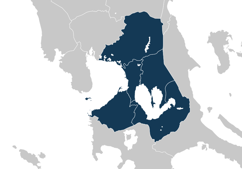
English: Map showing the extent of the "NCR Plus" area, a designation used for community quarantine measures in the Philippines during the COVID-19 pandemic. |
| Date | |
| Source |
This file was derived from: Ph regions and provinces blank.svg: |
| Author |
|
Licensing
[edit]

|
Permission is granted to copy, distribute and/or modify this document under the terms of the GNU Free Documentation License, Version 1.2 or any later version published by the Free Software Foundation; with no Invariant Sections, no Front-Cover Texts, and no Back-Cover Texts. A copy of the license is included in the section entitled GNU Free Documentation License. |
File history
Click on a date/time to view the file as it appeared at that time.
| Date/Time | Thumbnail | Dimensions | User | Comment | |
|---|---|---|---|---|---|
| current | 06:04, 6 August 2021 | | 878 × 613 (930 KB) | Hariboneagle927 (talk | contribs) | Uploaded a work by * {{F|Ph regions and provinces blank.svg|+}}: {{U|HueMan1}} * {{Derivative}}: {{Ut|Hariboneagle927}} from {{Derived from|Ph regions and provinces blank.svg|display=50}} with UploadWizard |
You cannot overwrite this file.
File usage on Commons
There are no pages that use this file.
File usage on other wikis
The following other wikis use this file:
- Usage on en.wikipedia.org