File:NATO World.png
Jump to navigation
Jump to search

Size of this preview: 800 × 364 pixels. Other resolutions: 320 × 146 pixels | 640 × 291 pixels | 1,024 × 466 pixels | 1,280 × 583 pixels | 2,628 × 1,196 pixels.
Original file (2,628 × 1,196 pixels, file size: 52 KB, MIME type: image/png)
Captions
Captions
Add a one-line explanation of what this file represents

|
This locator map image could be re-created using vector graphics as an SVG file. This has several advantages; see Commons:Media for cleanup for more information. If an SVG form of this image is available, please upload it and afterwards replace this template with
{{vector version available|new image name}}.
It is recommended to name the SVG file “NATO World.svg”—then the template Vector version available (or Vva) does not need the new image name parameter. |
| Description |
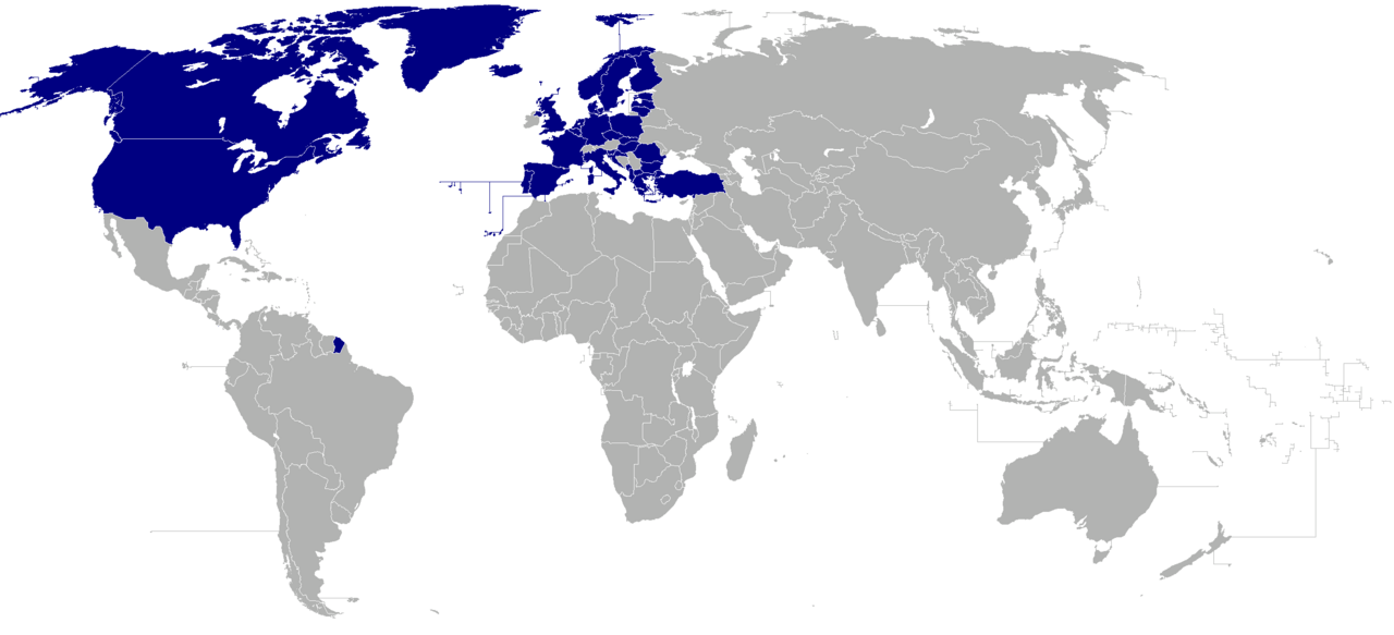
English: Map of the world with NATO member countries highlighted.
Countries highlighted are: Belgium, Bulgaria, Canada, the Czech Republic, Denmark, Estonia, France, Germany, Greece, Hungary, Iceland, Italy, Latvia, Lithuania, Luxembourg, the Netherlands, Norway, Poland, Portugal, Romania, Slovakia, Slovenia, Spain, Turkey, the United Kingdom, and the United States. |
||
| Date | |||
| Source | File:No_colonies_blank_world_map.png | ||
| Author | Joowwww | ||
| Permission (Reusing this file) |
|
||
| Other versions |

File history
Click on a date/time to view the file as it appeared at that time.
| Date/Time | Thumbnail | Dimensions | User | Comment | |
|---|---|---|---|---|---|
| current | 19:11, 7 March 2024 | | 2,628 × 1,196 (52 KB) | Iktsokh (talk | contribs) | Sweden |
| 22:53, 8 April 2023 |  | 2,628 × 1,196 (79 KB) | Flappiefh (talk | contribs) | + Finland | |
| 12:51, 3 October 2022 |  | 2,628 × 1,196 (107 KB) | GrandEscogriffe (talk | contribs) | + North Macedonia | |
| 01:02, 12 June 2017 |  | 2,628 × 1,196 (97 KB) | Ratherous (talk | contribs) | Montenegro | |
| 12:43, 14 April 2014 |  | 2,628 × 1,196 (97 KB) | Fobos92 (talk | contribs) | . | |
| 16:09, 24 December 2008 |  | 1,357 × 617 (28 KB) | Joowwww (talk | contribs) | forgot greenland and french guiana | |
| 16:00, 24 December 2008 |  | 1,357 × 617 (28 KB) | Joowwww (talk | contribs) | {{Information |Description=Map of the world with NATO member countries highlighted. Countries highlighted are: Belgium, Bulgaria, Canada, the Czech Republic, Denmark, Estonia, France, Germany, Greece, Hungary, Iceland, Italy, Latvia, Lithuania, Luxembour |
You cannot overwrite this file.
File usage on Commons
The following page uses this file:
File usage on other wikis
The following other wikis use this file:
- Usage on ko.wikipedia.org
- Usage on pt.wikipedia.org